The plan.... Paddle 500 miles on the Yukon River. This time it would be different. Looksha Lori would go. It would be Looksha Lori and me... no kids... just us this year. It has been a very long time since Lori and I had a trip like this alone. I was to drive and Lori would meet me in WhiteHorse 4 days after I left.
Well, that was the plan anyways...
Traveling just outside of Lytton, B.C. Everything is looking good.
Helicopter going down the Thompson River Canyon.
I drove 700 miles on my second day of travel.. not by choice.
Seattle to Cache Creek was wonderful. I saw Bighorn sheep on the road just before Cache Creek at Spences Bridge. I was able to get some pictures and video.
Looks like this one wasn't so lucky. Cougar I assume.
From Cache Creek north it rained like I have never seen before... all fricken day. At times driving was near impossible as the rain came down faster than my wiopers could clear the windscreen. I took the cutoff over to Kamloops and headed north on the Yellow Head highway. I arrived in Valemount and there was a reprieve in the rain, however, the road to Jasper was closed due to flooding. Even worse, the the road north to Prince George was closed due to a mudslide. I was told the mudslide would clear by 10 p.m. that night. Mother nature had other plans.
The great fakeout. Valemount was beautiful... for 5 minutes. Then all hell broke loose as the gods pissed on us for hours and hours
I found a nice campground by the swift river. As I was setting up it was if a faucet was opened to full... check that... it was like 20 faucets. A motorcycle rider from Penticten was trying to get dry in the camp cook shelter. We both moved our tents under there… where we spent the night. Next morning, it was drizzly and as I pulled onto the road... it was blocked. Damni it!! The RCMP had shut down the highway and stated that the slide got worse overnight form the severe rain. And the road to Jasper just had a slide. There was no way to go north for at least a day. My only choice was to head back down to Kamloops and cut back over to 100 mile house… a 350 mile detour. This country is BIG!!
A quick stop in Williams Lake visitor center.
I guess this is a typical weekend outing for the people in this part of the country.
With gas prices hovering around $6 per gallon, the SUV has been downsized, but not their fun.
Later that night I made it to Smithers. It was raining, but it looked like it might let up. I spent the night in Tyee Provincial Park where I met Gladys again (the Park Facilitator Operator). She recognized me from our previous trips... she asked about Johann. Gladys let me set up under the group campsite cook shelter. So I was warm and cozy for the night. I left Smithers in the rain... heavy rain.
My camp at Tyhee Provincial Park... in between rain squalls.
This is Morice Town and the Selwyn River
Looks like the first nations aren't too happy with Enbridge either. Working together we can stop them. Read more here in the article "Oil in Eden". What's at stake is more than a pipeline. What kind of world do you want to live in?
Junction 37... Start of the Cassiar Hwy.
The first rest stop didn't look to promising. Something about outhouses flooding into the river doesn't seem right.
The rivers wer very high and I was to get through the Cassiar hwy to the Yukon w/o any trouble.
Here is some more of what I saw in my 1 day drive up the Cassiar...
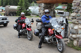
In Bell II, where I got gas, I saw this cute couple from Austrailia traveling North America on BMW 1150 motorbikes. They were a hoot to talk to. The rain didn't seem to phase them. They reperated the old saying that there is "no bad weather... only bad clothing". I disagree. Had they rode through what I drove through they would change their tune I'm sure.
These steel gate bridges are common along the Cassiar. Many still have wood decks and are usually single lane.
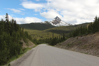
Every now and then I caught a glimpse of some beauty in between the rain.
This picture was interesting. I was rounding a curve and this black bear was sitting in the road. I wanted to stop, but I had a "megaton" logging truck on my heels and stopping was out of the question. With the steering wheel in one hand and the camera in the other, I was able to take a sequence of pictures of this guy scrambling.
Just outside of Iskut is where some fantastic wilderness areas exist. I keep telling myself that someday I'll explore this area more. Mt Edziza park is here, A hidden jewel. Someday
As I approached Kinaskan Provincial Park I see this cute little creature.
As I drove toward him, he decided to play chicken with me and bolted, not into the woods as one would expect, but rather... right in front of my truck.
I assume that since I was at the park entrance, he wanted to race me to the garbage bins and get first pickens. Fine with me :-)
Next stop...the Stikine River.
Under normal conditions, this river is tricky at best. With the flooding, giant logs (old growth forest) were washing down the river and making rather large waves on the shore. Soon after this picture, I had to move rather quickly as a giant snag was coming for me through the high bank brush. CRASH!!!
Mt Edziza park can be seen here. It was at this point I noticed the sagging of the kayaks in the rear of the roof rack.
A close call. The rear rack had slid down the main rack on the canopy and was only held in place by the strap that I had tied around the Yakima rack and the canopy rack.
I cannot stress enough the importance of practising multiple tie down points. The redundnancy saved the boats, the trip and the vacation. One can clearly see the strap holding the enitre system on here. My kayak sitting on the canopy bar. Luckly, no damage. WHEW!!
Later that day on the Cassiar
I stop at Jade City (Looking North)
Jade City (Looking South).
I meet two gentlemen from Switzerland traveling around the world on bicycles. AMAZING!!
Lorenzo (left) and Julian (Right) travel about 50-60 miles a day. Since they were slow (relatively speaking) and in a remote wilderness, they missed all the torrent rainfall. Folks like these are true adventureres. How they do it, from both a financial and physical perspective is beyond me.
My final camp on the Cassiar hwy was at Boya Lake.
Boya lake is a special place. Always beautiful, peaceful and inviting.
Out side of Teslin, on the way to WhiteHorse, a couple of bears decided to play chicken with the roaring semi trucks. I hit the flashers and pulled over to the side and escorted these bears to safe passage. I'm not sure if they are siblings or a mother and a cub.
I wish them long and happy lives doing what bears do. Please be careful.
Stay tuned for more as the advneture unflods. Read follow along as we begin our Yukon River odyssey in this post: RubiKon Quest 2012: 10 Minutes From Nowhere - Day 1 on the River
Until Next time...
_0003.JPG)
_0005.JPG)
_0006.JPG)
_0007.JPG)
_0019.JPG)
_0025.JPG)
_0015.JPG)
_0031.JPG)
_0032.JPG)
_0034.JPG)
_0037.JPG)
_0040.JPG)
_0041.JPG)
_0042.JPG)
_0043.JPG)
_0044.JPG)


_0069.JPG)
_0075.JPG)
_0076.JPG)
_0080.JPG)
_0082.JPG)
_0084.JPG)
_0090.JPG)


_0129.JPG)
_0133.JPG)
_0136.JPG)


_0002.JPG)
_0010.JPG)
_0015.JPG)
_0018.JPG)
_0020.JPG)
_0024.JPG)
_0030.JPG)
_0031.JPG)
_0038.JPG)
_0041.JPG)
_0046.JPG)
_0047.JPG)
_0058.JPG)
_0059.JPG)
_0063.JPG)
_0064.JPG)
_0072.JPG)
_0073.JPG)
_0074.JPG)
_0087.JPG)
_0091.JPG)