An All (mostly) Dirt Route from Clearwater BC to the Bowron Lakes Gold Country ...
Start at the beginning and read
Part 1 here
Trip Summary
High Level Route Description
Snohomish
to Green Lake BC then over to Clearwater to Mahood Lake, to Canim Lake,
to Elbow Lake, to Crooked Lake (and a hundred other lakes in between,
not to mention all the rivers, streams and creeks), to Horsefly, to
Likely, to Bowron Lakes, then back to Likely, to Quesnel Forks (Ghost
Town), to Horsefly, to Williams Lake, to Gang Ranch, To Alkai Lake,
Kelly, Lake, Pavillion, Lillooet, Texas Creek Road to Lytton and finally
the Nicomen Road to Boston Bar and finally back home.
I
covered a total of 1500 miles ... Over 1000 miles of dirt! Dirt is in
every nook and cranny on the bike, luggage, camera... Heck, I've got
dirt in parts of my body I didn't know could get dirt. I've met wild
women (yes, a mountain guide living out in the bush by herself .. makes
great pizza BTW), young hipsters in broken down cars, old farts in
trucks, many natives, 7 bears, baby bob cats, 1 moose, 150 suicide
squirrels and chipmunks, drank numerous beers of all kinds, ate candy
bars, nuts, dehydrated food, bathed in a couple of rivers, survived a
hail storm, met my friends (Alex and Jenny) coming back from the Yukon
via moto bikes, passed two world famous bike travelers (Simon and Lisa
.. on their way to Alaska on their new BMW GS's), etc.
I
had to buy a new map... wore the other one out and/or used pages of it
for butt wipe. The "BC Back Roads Mapbook of Lies" ("Isn't there
supposed to be road here?" is the question I find my self asking over
and over again. ). Awe yes, that's all part of the adventure. U-Turns
included in the total mileage count... Sigh?!
////////////////////////////////////
After doing some laundry and getting a much needed bath, I saddled
up and decided to head back out to Likely.
 |
| These signs appeared every so often (Complete with coordinates) |
I took a brief detour to Barkerville, I even thought
about taking a walk through town. However, I arrived and the parking lot was crowded,
and there was an entrance fee. The last time I toured Barkerville in 1998, it was
free to enter then and there were hardly any people. No thanks.
So I headed out to Likely, retracing the route I did the
day before. I felt a bit guilty for retracing my steps and not exploring some new ground , however, the road is such
an incredible ride, I had to do it again.
 |
| Cariboo River flowing out of Bowron Lakes Park |
 |
| Awe, back in the Cariboo Moutains |
I took my time and had a very lazy and relaxing ride back to Likely.
At one point I came across 3 bears (a sow and 2 cubs). As I came around a turn and they were in the middle
of the road. Mom quickly herded them into the bush. They were much too fast
for me to reach my camera. I did pull over a bit down the road and setup my
camera, just in case they came back out, but after 15 minutes of waiting, I
decided to saddle up and continue my trek.
I came across some octagon cabins I saw the day before. I
believe the place was called Comet Creek. There was no one here. The cabins
were open and were complete with furniture, stoves and such. The place reminded
me of a hippy colony. I am not sure why. Maybe it was the name, maybe it was
the odd shape of the buildings… I dunno.
Back on the bike I headed back to Cameron Ridge. It was getting
late in the day by this time and rain clouds were forming. I rode through
various starts and fits of rain. The mountains next to me were engulfed,
complete with lightening. Yowza!!! I
decided not to stop at the Chocolate Moose Café because of the lateness of the
day.
 |
| Humble bumble bee |
After Cameron Ridge I came across another big minefield
of bear scat. It littered the road and looked similar to what a herd of cattle
may have done if they had passed this way. Holy bear scat, it was soo fresh and
in the heat of the day, I could smell it. Not really that bad actually; but my
tires got pretty soiled with the stuff. It wasn’t long and I soon saw another
big black bear ambling down the road in the distance. This time I tried to sneak up on him/her
and get some photos and maybe even a video. I stopped and slung my digital SLR
around my neck and turned the GoPro on as I make a stealthy approach on my
Gretchen. I turned a corner where the bear should be and NUTHIN!!! Poof, the
bear was gone. The only sign was a fresh pile of scat … I went a bit further up
the road and did a u-turn. With camera poised and the engine off, I was ready
for the black beast to appear on the road. After a bit of a wait, I gave up, putting
the camera away and taking off. About a
mile later, I see another bear… but it was too late, he jettisoned off the road
like a rocket.

I eventually came upon some beautiful flowers and thought
it would be a great place to rest a bit and down some water. Bumble bees where
busy doing what they do… pollinating the flowers. I think I got some pretty
good video of these little creatures. I don’t know what it is about bumble
bees, but I have always found them to be fascinating, even cute. I am very fond of them. They fly about
doing their business without a care in the world. They never seem to notice
people and better yet, could care less about me standing among them taking their
pictures. Now, why can’t bears be more like these bees?
 |
| Gretchen enjoying the pretty flowers |
 |
| One of 3 Cariboo River crossings |
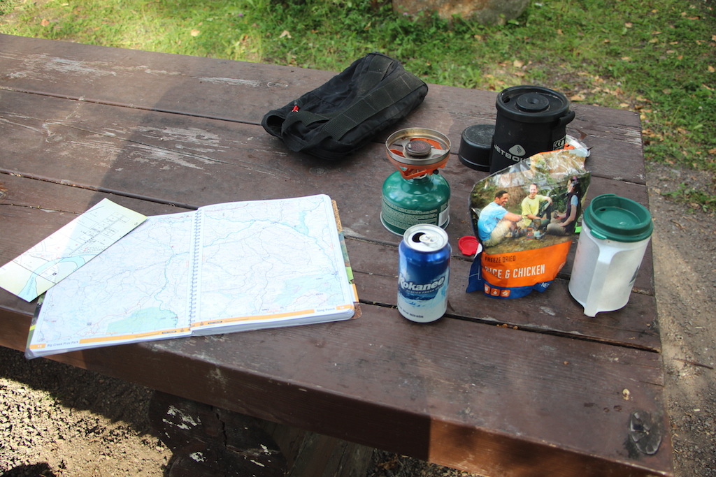
I spent the night in Quesnel Forks and upon my arrival, there
was a group of rafters packing up. They had just finished floating the Cariboo
River. After they left, I had the entire
town to myself complete with all the ghosts :-)
 |
| Dinner at Quessnel Forks.. Kokanee, chicken and rice... Yum |
 |
| Setting up Camp at Quesnel Forks |
It was a quiet evening, however, sometime during the night, and
old man showed up in an SUV in the camp slot next too me. I watched him a bit and then noticed he went down to the river to fish late into the night.
Apparently he slept in the back of his vehicle and came out to fish again in
the morning while I was having my breakfast.
 |
| Ditch Road back to Horsefly |
During breakfast, I poured over my maps to plan my next move. I decided
that I should ride the Ditch Road back to Horsefly and then out to Williams Lake as I have never been on that route. It was a beautiful ride
through some mature forest that hugged the bluffs above the shores of Quesnel
Lake.
 |
| Horsefly Lake |
I took a side trip to Horsefly Lake to check it out while
I was there. Like all the other lakes in the Cariboo Region it was hard to see
the lake because of the thick forest surrounding it on all sides.
 |
| Refuel on food and snacks |
From Horsefly, I headed out towards Williams Lake. My
plan was to head out to Dog Creek and skirt the edge of the Churn Creek
Protected area. My route would take me high above the rim of the Fraser River
canyon out there.
 |
| Easy Rider at Williams Lake |
I stopped for lunch in Williams Lake and a gent with a Can Am pulled in with a dog riding on the back of the bike. The dog was sporting “Doggles” and looked like he was having a great time.
 |
| He's (she?) cool |
 |
| Alkai Lake |
At this point, the heat was rising pretty fast. I left Williams Lake with the temperature hovering around 90 degs… It was bit hot for me and my level of discomfort was rising quickly.
 |
| Alkai Lake is a waterfowl preserve |
I rode through the village of the Alkali Lake Band first
nations. I got friendly waves from the locals and stopped to chat with a couple
of them to learn more about the area. I got a bit of background about them and
their recovery from alcohol. They live on the cusp of the Chilcotin Plateau. The
road through Alkali Lake is a one of the gateways to this beautiful country.
 |
| Awesome canyon that I rode up |
The valley through this area is not only beautiful, but the lake is set up as a reserve for waterfowl of all sorts. I was able to witness some swans frolicking in the lake from a wayside view. I am hoping that my video I shot is able to capture some of this.
 |
| Selfie ... it was hot 92 degs!! |
At the west end of the lake, the road started to gain
altitude up to a big ridge. From this ridge, I was able to gather some nice
views of the Alkali valley from where I came. It is really nice country to tour
on a motorcycle.
 |
| Fraser River Canyon... Beautiful |
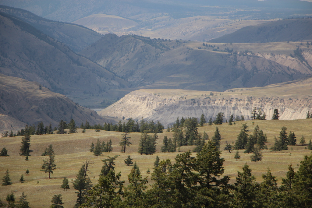
Leaving Alkali canyon and crossing the ridge to the other
side blew my mind. I found myself on the rim of the Fraser River Canyon. Awesome
views of the formidable Fraser River flowing from the north in the deep canyon
gorge are hard to describe with words.
 |
| Fraser River Canyon... bring it on |
I have been in this area before, traversing the canyon
from the southern portion, coming in from the area known as Canoe Creek.
However, this area was even more dramatic with its’ steep cliffs and grand
vistas.
This area is just south of the Junction Sheep Range Provincial
Park. Just a bit farther north is the confluence of the
Chilcotin and Fraser Rivers. A place I hope to visit someday.
Despite the heat… it was hovering between 92-98 degrees by this time... I found myself stopping very often to soak up the views and really let my mind wander. I was wishing that the weather reports were wrong, but I could see that dark clouds were forming over the Chilcotin Plateau and that rain was certain to follow according to the weather forecast I read.
Since words can't describe this area, I'll let loose a plethora of pictures here to share my experiences.
 |
| Cacti Plants |
 |
| Gretchen giving her best pose. |
 |
| I kind of like this place |
 |
| Scenery so stunning |
 |
| On my way to Dog Creek, but first |
 |
| That's the mighty Fraser River folks |
 |
| Looking west, I could see the clouds forming over the plateau |
 |
| This guy kept following me. Every time I looked in the mirror, there he was!! |
 |
| Now that my friends is a motorcycle to heaven |
I finally reached an area I recognized. I had arrived at the start of the Churn Creek Protected area. The Gang Ranch Bridge spans the Fraser river somewhere below in the canyon.
Form this vantage point I could see two motorcycles scrambling their way towards Gang Ranch. I hung out a bit to enjoy the grand views and just as I was getting ready to leave, the bikers came speeding back down towards the canyon and headed up my way.
 |
| Looking into the Churn Creek Protected Area |
The two bikers were looking for a beer I guess and told me that there was nothing at the Gang Ranch, so they turned around (huh?!? I said silently to myself). In any event, one fella was riding a R1200 GSA like mine while the other gent was sporting a brand new KTM 1190R. We couldn't talk long because the road was narrow and a big truck was coming our way, so we parted ways.
I made my way down in elevation and looked back at the Gang Ranch Bridge. My heart begged me to turn around, but weather was settling in just to the west. I feared that it wouldn't be long before rain would follow as predicted by the forecast.
I've ridden on the wet roads of the Chilcotin before. They are not fun. Think of trying to ride on a tile floor smeared with vaseline and add in some fender clogging mud and you get the idea. The locals have told me that the roads can be tough even in a 4x4 and they stay off them during such times.
 |
| Gang Ranch Bridge... Coming back in a few weeks |
 |
| More Fraser River... see dem clouds in the background |
I was in no hurry to ride through here. I stopped several more times, drank some water, sat and absorbed it all in while sitting on the side of the canyon just relaxing.
 |
| Passing through Canoe Creek 1st Nations village |
I eventually pulled away from the Fraser Canyon and rode through the Canoe Creek 1st Nations village. The sun was getting low in the sky by now and I was hoping to make it to Lillooet before nightfall.
 |
| On my way to Poison Road |
On my way to Poison Lake Road the sunlight provided a real show on the limestone rocks.
 |
| Directions... so much good stuff. Hard to choose |
I finally arrived on the Jesmond Road and thought twice about heading over to the Big Bar Ferry. It was getting late and I don't think the ferry was running anymore today.
Instead, I headed over to Kelly Lake and took the Pavillion cutoff road towards Lillooet.
 |
| Start of the Marble Range |
The ride past Big Bar ranch was fabulous as always.
 |
| Big Bar Range... Guests can stay in Teepees |
 |
| Marble Range just ahead |
Soon glimpses of the Marble Range began to appear and again my mind began to wander.
 |
| Riding through old fire burns in the evening sun |
The evening sun was surreal and all was quiet, I was expecting to see cattle on the road, but there was nothing, not even another car for about an hour. It was great to ride quietly through the still country side.
 |
| Pavillion cutoff road |
About midway through the Pavillion cutoff I came across some "hippy" kids that were having car troubles. I helped them out, gave them some advice and they would soon be on their way after their SUV cooled down a bit (long story of what their problem was).
 |
| One of my favorite roads out here |
The sun was starting its decent behind the mountains and every minute it began to get darker and darker as dusk was fast approaching.
 |
| BC's Little Nugget - Lillooet |
I arrived on the outskirts of Lillooet just in time to witness a fantastic sunset. I sat along side the road for 15-20 minutes and only moved on when a 2 person bicycle passed me by. They were loaded with camping and travel gear. I had to get some video footage of them. So off I went, with my GoPro in hand. I am hoping that the footage came out. I paralleled them in the opposite lane for a spell to video them while they waved and smiled. I was pleasantly surprised to see that it was an "older" couple enjoying their retirement years in a BIG way...
 |
| Thompson River as I ascend up the Nicomen Road |
The next morning brought with it a few surprises. First and foremost, it was 'hotter than a pistol" as my dad would say. I stayed the night in the hotel deoro. Not many choices for accommodations in this town. But they did have air conditioned rooms and a nice continental breakfast.
After breakfast I finished loading my bike and went to the Petro Canada station to get some gas. They were out of premium fuel,so I had to, once again, fill up with regular unleaded. Not so bad, but over the next few hours my bike ran like shit. There must have been water or something else in the gas. Given where I was riding, Texas Creek Road, high above the Fraser River on cliffs on a dirt road. I was very concerned as the bike stuttered and "knee jerked" at the most inopportune moments. Several times while accelerating the bike would cough and slow all of sudden, I nearly lost my balance and went down... to make things worse, there were cliff side curves on this dirt road. Yikes!!
In any event, the best part of my visit in Lillooet was meeting 3 other fellow GS riders from Idaho/Eastern Wa. They were on a 9 day mission to ride out to Bella Coola but got lost out on the Chilcotin Plateau. They were navigating by GPS and didn't have any good maps. Running out of time, they came back in.
I gave them a grand tour of Texas Creek Road to the Lytton ferry. We all had a great time riding in the heat with bad gas. It was HOT though and we were all looking for some place to cool off. I told them that I was heading back towards Hope on Hwy 97, but I was going to take this dirt road I heard about to Boston Bar, along the Fraser River and re-join the hwy there. Along the way, I knew of a waterfall. So after crossing the Fraser River on the Lytton Ferry, we headed along the Thompson river to the Nicomen River. There is an impressive waterfall there. We all stopped to cool off. For the first time, I used my new apparel, a cool vest. I soaked the vest in the icy mountain river and put it on. NICE!! Why didn't I use this earlier? I parted ways with the other riders at this point. I think they have had enough dirt for the week. I was uncertain about the road I was about to embark on as well. I told them that I was told that the Nicomen Road was big bike friendly, but I personally had no experience with it.
 |
| WOW!!! What a view. The Thompson River from upon high |
So off I went, solo again. I climbed the Nicomen road very quickly on STEEP switchbacks and came across two black bears running across a meadow ... away from me. I believe I got them on my GoPro camera this time. In any event, the road topped out and became a bit "rutty" with big muddy ponds spanning the road. Not a problem as I was able to ride around most of them. The Nicomen road had many, many spurs and forks, all of which looked like the main route. I took many of these roads only to see them veer off in what I thought was the wrong direction. My map book was of very little help and neither was my GPS.
Once again, I found myself on a narrow logging road littered with bear scat. The road eventually appeared on my GPS. It seemed to get progressively better and appeared to be more traveled the closer I traveled to Boston Bar. I eventually came to a T in the road. I took a right turn and eventually made my way to Boston Bar with no issues.
I had a pretty non eventful ride back through Yale, Hope and eventually to Abbotsford where I crossed the border back into the USA. This was one of my favorite moto trips. There was nothing technical about it from a riding stand point. The entire route is easily doable on most bikes. If you are willing, I would say that a street bike would have no issues, although it may be a little rough on street suspension, especially out towards the Chilcotin Plateau area along the Fraser River. I will return someday. The Chilcotins are just too beautiful to resist and most definitely some of the finest scenery in all of Canada, especially if one gets back there far enough. I took lots and lots of video so look for a video production at some point.
Until Next time....


 I was in no hurry to ride through here. I stopped several more times, drank some water, sat and absorbed it all in while sitting on the side of the canyon just relaxing.
 After breakfast I finished loading my bike and went to the Petro Canada station to get some gas. They were out of premium fuel,so I had to, once again, fill up with regular unleaded. Not so bad, but over the next few hours my bike ran like shit. There must have been water or something else in the gas. Given where I was riding, Texas Creek Road, high above the Fraser River on cliffs on a dirt road. I was very concerned as the bike stuttered and "knee jerked" at the most inopportune moments. Several times while accelerating the bike would cough and slow all of sudden, I nearly lost my balance and went down... to make things worse, there were cliff side curves on this dirt road. Yikes!!


