RubiKon Adventures

Tales and travels of "GrizzLee", "Looksha Lori" & "Yukon Johann"


Monday, October 28, 2013

Day 2 - Destination Nuxalk Nation: A Solo Adventure Ride to Bella Coola


Day 2: Bridge River Beauty
“We all strive for safety, prosperity, comfort, long life, and dullness.”   ~ Aldo Leopold

 
Video: Day 2 Bridge River Beauty

My morning on day 2 began with thick layers of fog.  Surprisingly, I slept good, albeit, a little wet because of the blanket of fog that had engulfed the valley overnight. I had large drops of condensed water coming off the trees onto my tent and this is what woke me from my sleep.
View from my morning camp on Lillooet Lake
With the daylight, I was able to see more clearly my neighbors with whom I camped. It turns out, I was a bit more cozy with them than I imagined last night. I really wanted to take dip in the lake to clean up, but the lack of privacy kept me from doing so. But, that could wait until later. After a quick breakfast, I packed my soggy tent up and headed down the road toward Pemberton. The road along Lillooet lake was in really bad condition. It was pretty rough, even by motorcycle standards. It really exercised my suspension and my ass. Eventually the fog gave way to sunshine and 
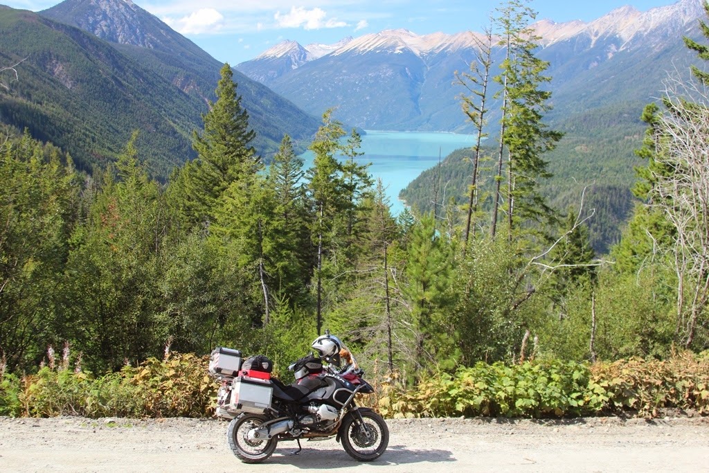
I was beginning to get excited about my trip again.
The fog lifted and the views were priceless

I re-fueled in Pemberton with both, breakfast and premium unleaded. I then proceeded further into the far flung reaches of southwest BC on the Pemberton Meadows road. I was on the fringes of the glaciated coastal mountains. I headed up the Hurley Forest Service road over to GoldBridge. This road was awesome. I gained elevation really fast and the soon found myself above the valley floor with great views in to the heart of the mountains.
Hurley road is amazing
It was hard to make fast progress as each corner rewarded me with great views. At one point I was mesmerized by the views into Dowton Lake. I stopped for quite awhile here to admire the scenery.

View of Dowton Lake from the Hurley Road

 
Not far from there, I stopped at Goldbridge, an old mining town with a population of 43 people, and had a snack. I then proceeded up to Bralorne mining town and had a look around, including a quick tour of the mining museum. It is quite the place to see.  For any biker, visiting the bridge river area is an unforgettable experience. I can see that any dual sport rider would love to ride any numerous road options here as they all offer fantastic vistas and challenges for all skill levels.


Old mining towns and abandoned bldgs

Welcome to Goldbridge... Population 43
Leaving GoldBridge, I proceed very methodically along Carpenter Lake. Carpenter Lake is a real gem of ride as well. The lake is just over 50 kms in length, but I would take more than 3 hours to ride it. I stopped several times to savor the beauty and waterfalls in this deep canyon.
Pictures don't lie...
 
Carpenter Lake was spectacular

Hmmm, hmmm, hmm, good!!

 
At the end of Carpenter Lake is a dam where the road winds its way through a narrow canyon.


The road and the river wind through a narrow canyon

Magic


Cool ride -- One of the best motorcycle roads ever


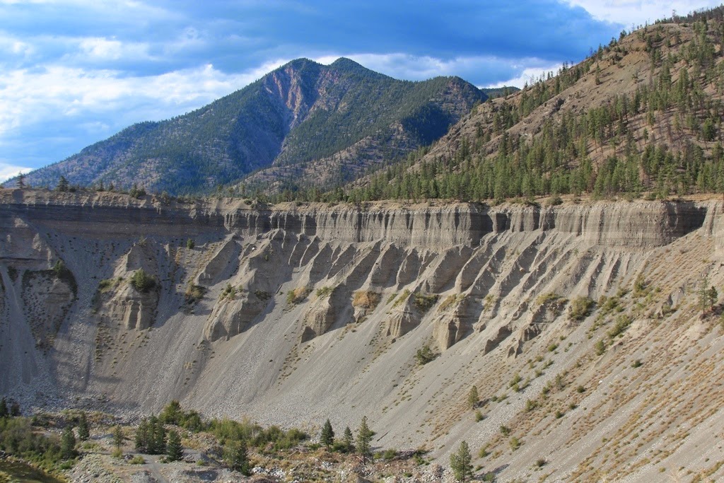
The geology has a story to tell


Both the road and the Bridge River would continually wind its way through the mountains. It was fantastic and mode for a very special riding experience. For several miles, the road hung precariously along the cliff wall, without guard rails and with the river far below at the base of a cliff.  This was not a ride for those afraid of heights. Eventually the canyon mated up with the Fraser River and I passed the West Pavilion Road; A road I was to ride the next day. I spent the night in Lillooet.
Old buildings and cabins dot the countryside, adding to the experience 

Exiting into the Fraser River Canyon to Lillooet

Until Next time..

Stay Tuned for Day 3...

Friday, October 25, 2013

Day1 - Destination Nuxalk Nation: A Solo Adventure Ride to Bella Coola

 Day 1: Seattle to Lillooet Lake… The Hard Way 


“What avail are forty freedoms without a blank spot on the map?” ~Aldo Leopold


Video - Day 1: Seattle to Lillooet Lake.. The Hard Way

I left a little later than I wanted to this year. I said goodbye to my family around 10:00 a.m. as I left my home in Sammamish, Wa.

Leaving Home


From there, I took Washington state route 9 to Sumas, Wa where I would cross the border. This route would normally be quite fun and interesting for many folks. The sunshine, glimpses of the mountains and the secondary growth of trees are beautiful for sure and for many metropolitan loving folks, that can be a very exciting adventure in itself . But for me, it was all too familiar, as I have traveled it numerous times on my journeys to/from Canada. I see it more as a gateway to the real beauty that is only found north of the lower 48 states. However, there is one very scenic spot where one can see across a valley, past clear cuts at the start of the North Cascades foothills, where Mt Baker gives a peek-a-boo glance to passing travelers.

Mt Baker Teasing me with partial views


Mt Baker is a volcano that, from this road, provides a real tease like at a burlesque club, where you don’t get to see it all, and the mind is left to its own devices to fill in the blanks.  However, for me, crossing the border into Canada is always stress full experience and the views, no matter how interesting, are not enough to release the pressure I feel when I arrive at the border. The border guards in addition to the typical  “where are you from” and the “where are you going and for how long” questions,  always ask me “are you carrying a knife/bear spray/guns”.  It seems that whenever I mention that I have Bear Spray, I get pulled over and they do a full body cavity search where I spend the next hour re-packing my gear and it never seems to fit right. So this time, I lied and said no. After a few inquisitive questions as to where I plan to camp, I was set free and on my way to Mission B.C. The border guards even got a free geography lesson for me as I tried to explain where the Naxulk Nation was located. All I got was blank stares. I must admit, I felt a bit guilty and it bucks my normal persona. But, I had had too many bad experiences at the border and besides, I quite enjoyed stumping them without coming across as a smart ass. 


The plan was to ride the West Side road on Harrison Lake. Harrison Lake It is a real gem and can be pretty hairy on a fully loaded GS towards the north end of the lake. 
My Route for Day 1 (click to enlarge)
I arrived at the Sasquatch Inn, where there were numerous bikers and it appeared that a number of folks from a classic auto club were also there enjoying lunch and chewing “the fat”. I had a quick snack and took off up the road towards north.  It wasn’t long and the pavement gave way to gravel.


Harrison Lake and its emerald beauty
Soon, I was getting glimpses of the emerald colored lake. Although, no one could see it, I was wearing an ear to ear grin in my helmet. The next four days, I would see very little to no pavement. I was in heaven. Because I was covering ground that I rode last year, I was going a bit faster than last year, with less “scenic” stops. Besides, it was now pushing 3:30 pm and I needed to get to Lillooet lake before dark as I left home about 4 hours later than I should have. 
 
Beautiful Harrison Lake nestled in the mountain landscape like a childhood storybook scene

Heading farther north, the mountains get bigger

As I approached the northern end of the lake, the road conditions dramatically changed. The upper end of the West Side Road along Harrison Lake can get pretty rough. In fact, in some spots it is damn near a 4x4 trail. Although it was a bit hairy last year on the big GS, I felt confident that I would have no problems getting through the roughest sections. My troubles all began after a mild water crossing. The road got narrower and the loose rocks got bigger, many about the size of softballs, some even near the proportions of a petrified dinosaur egg I once saw. It all seemed pretty manageable at first, but then I met a local who was out camping and he warned me of the road conditions ahead for the next 7 Km’s. Like most Canadians, he expressed genuine concern for me and my safety. I told him that I was here last year and it wasn’t that big of deal. He told me that this year was different. He told me that he had trouble going through earlier in the year on his 250 cc bike. I am quite certain he was looking at me, my bike and all my gear while thinking all the time that I must be some kind of inexperienced nut. He stated that in a bit he would drive up behind me for 5 kms to help me in case I had in trouble. For that I was grateful and heartily thanked him. From there I encountered the first real challenge. The road not only angled up steeply, but it leaned downhill towards the lake as it angled up and, in many cases, has severe drop-offs to the lake below. All the while, the sand that normally held the rocks in place was washed away from the severe rains that happened a few days before, making traction a real chore. At times, my rear tire was spinning so much that I could smell the rubber. Dumping the bike along this stretch and falling off here could result in real injury. I was very concerned. 
 
A slide partially blocks the road


It wasn’t long before I encountered a fellow GS rider coming the opposite direction. We recognized each other. His name was Lucias(sp?) and we happened to meet up in the Yukon as I was heading south and he was heading north just a few weeks before. What a small world. We talked a bit out our experiences to Prudhoe Bay and how dirty our bikes got. In any event, he told me he had dumped his bike twice already and wondered how much further the rough stuff was. Likewise, I asked him how far I had to go. From my perspective, it wasn’t good. I had another 5 to 7 Kms of hell to ride through. Lucias was nearly finished with the bad stuff. We parted ways and then it wasn’t long before I dumped my bike. A first for me. I wasn’t too shocked. However, in the process, my foot temporarily got pinned between the bike and the ground. I lost my balance and fell, bruising my knee pretty good. Not damage to the bike. I was fortunate enough to have a couple of quad riders come by and they gave me a hand in lifting my loaded bike. 
 
O-boy.. What have I done here

At this point I was soaked with sweat and drops were running down my face and neck form within my helmet. I proceed  another couple of kilometers, passing a truck canopy that had come off a truck. It was lying in the middle of the road. From there I crossed several rocky ravines, including one that was pretty precarious with a rocky cliff dropping off several hundred feet above the lake. One fall here could result in real pain, maybe even death. In these areas, I moved my bike methodically and slow, inch-by-inch, foot-by-foot. I wasn’t taking any chances. All seemed to be pretty good and the road appeared to be improving when I hit a small ravine and fell over on my bike for a second time. I took a pretty hard spill and really plowed my head into the rocks. Luckily, I had my helmet on. This time, I dented my pannier up pretty good. My engine guards got pretty beat up as well. I was alone for a bit and I tried to lift my bike, but the rocks were like marbles and I felt the bike sliding along its side. I couldn’t lift it. I began the process of dismantling the luggage to lighten the bike up, when a lone endure bike rider came up behind me. He gave me a hand and I thanked him before he went on his way. 

The Waterfall Signifies that the Worst Is Over
 
The end of Harrison Lake.. Whew, what a ride

My Route along Harrison Lake (Click to enlarge)
 From there I was thankful, as I was finally out of the worst of it. My body was soaked in sweat and my mood wasn’t all that great. It was beginning to turn dark and I still had a ways to go before I made cap at Lillooet Lake. As I pulled into the logging camp in Tipella, I was mildy amused by a log formation in the water. It seems that mother nature was against me. The log looked like a fist with it’s fingers curled in a fist, save for the middle finger. Yep, mother nature gave me the bird. 

Mother Nature Gives Me the Finger

From there I made time as fast as I could. I was in a deep fjord valley following the Lilloet River and darkness settled in pretty quickly. The temperature dropped and the sweat pouring off my body drenched my clothes. I began to shiver a bit. I arrived at camp around 9:30 in pitch black darkness. To make things worse, my batteries in my LED headlamp were nearly dead and I was forced to use the light form my cell phone to make my way around and setup my tent. I had a lonely dinner by the lake that night. The fog rolled in soon after and I soon found myself asleep. Man, what a day this was. I can only hope it gets better tomorrow.

Stay Tuned for Day 2.....

Wednesday, October 23, 2013

Prelude - Destination Nuxalk Nation: A Solo Adventure Ride to Bella Coola


Coming off an epic ride with my son to Alaska (see Our Life Behind Bars: Father & Son Doing Time in the Northern Frontier) one would have thought I would have been done riding for the year. And the truth be told, I was ready to put the bike away and do a paddle trek in Central B.C. in kayaks. I have not put my Kayak in the water since returning from my Yukon River Paddle expedition last summer (See  our blog). A good friend and I were to take off the week of Labor Day to do just that. However, due to circumstances beyond his control, a pending layoff and forced overtime work schedule, didn’t allow for the trip to pan out at the last minute. While I could have gone by myself, I have never really liked trekking solo in a kayak or with a pack on my back into remote backcountry for safety reasons. Besides, rarely do I find conversations with myself that interesting, nor are the voices in my head very comforting at day’s end on these types of trips. Now, riding motorcycle solo; that’s a different thing you see. I could bring some amenities along to bide my evening time. Plus there is the possibility of grabbing a good meal on the road, something that lightweight dehydrated food just doesn’t compare to. When the paddle trip fell through, I quickly gathered my gear and formulated a new plan. That plan was to go back to the wonderful country I discovered 2 years ago. Back though the Chilcotin Plateau through remote country, canyons, sage, woods, mountains, rivers and glaciers to the Nuxalk Nation country… also known as Bella Coola to us anglo’s.
Video Trailer of my 7 Day Expedition

Now this trip may sound familiar to those that know me and for those who read my report from last year (Bella Coola Ride Report here). But hang tight. This is a completely different experience for many reasons. For starters, the route I took was different and the wildlife I saw was much more interesting. Now I pride myself in being a cautious man when it comes to riding bikes, especially when I ride solo into remote areas. This trip was no different.  However, you’ll see candid photos and video of a middle age man having fun, dumping his big bike (A first for me on my big GS),  see me nearly cry and you’ll see what mother nature thinks of me… I can tell you that it isn’t always pretty. You’ll also see photos of Grizzly bears taken from the seat of my bike… one hand holding the camera and the other hand on the throttle. Yes, I threw caution into the wind and took on one my most challenging and rewarding solo motorcycle adventures yet.

Many folks have contacted me and asked for a packing list and photos of my gear. I must get around to that someday. Not on this trip… I will however, tell you that I bring lightweight gear that transfers directly from my backpack to my panniers (light weight 3 season tent, cook stove, etc.) with a few exceptions; I bring a very comfortable sleeping pad, camera, GoPro, extra batteries, iPod, laptop (to dump the photos and the videos and to check email). Additionally, I carry my tools, a small air compressor, extra tube, extra oil, my Garmin Etrex, a personal locator beacon , long underwear for those cold frosty nights, a pair of lightweight cross trainers, a cell phone, maps, good conversation and a positive attitude to keep me company as I make my way through this country of lonely roads. As many can attest, adventures are just as much a mental experience as they are a test of physical endurance.

My route is a sight to behold in any vehicle, but it is best traveled by motorcycle. I have found that there is not a better way to experience the country. On a bike there is always a sense of danger, wonder and one can excite the senses as you can smell and taste the land. I’m not talking about just any bike either. To truly experience this grand land, requires something more than a highway cruiser, crotch rocket or a moped. To take a journey of these types of bikes is like inviting a vegetarian to an all you can eat steakhouse. Once you get there you’ll see why it isn’t going to work, no matter how hard you try. Nope, there is only one bike for the job. That is an all purpose bike that can carry your gear, travel pavement legally, perform well enough in the dirt (mud and sand) to get you there in one piece. We are of course talking about a dual sport motorcycle. For me, there can only be one bike. My beloved Gretchen, a 2009 R1200 GS Adventure.  But of course, you already knew that. And you probably feel insulted just having read that last sentence. Let me tell you my friends, the last thing I want to do is to insult you or waste your time. Please read on and enjoy the report. I’ll try not to disappoint.  
Stay Tuned for Day 1. 
Until Next Time....

Sunday, October 20, 2013

Cool Ride Around the Olympic Penninsula

The Last Big Ride of 2013? Maybe so.

With the weather changing quickly into the Pacific North West fall season, the weatherman said we were in for a treat. The Washington coast was supposed to be dry and warm. 70 degrees in Astoria.. Mr Weather man... are you kidding me?? Yep, Sunny and warm. So off we went for 3 days. Father and son doing the Olympic Peninsula.

Long Beach on bikes near Beard's Hollow


Johann rode a Kawasaki 650 Versys


Dinner on the pier in Astoria

Fish 'n chips out doors with a full moon,
golden-orange sunset and sea lions chatting up a storm.

On the way up to see the Astoria Column


We rise above the fog and see this.


The Astoria Column

Crescent Lake in the Olympic National Park

Looksha Lori met up with us and brought the family dog


Kamiah is a golden retriever. She is attracted to water like a magnet.


Along the way, Johann picked up a passenger

It seems that Mr Coyote thinks the Versys is a more reliable way to catch Road Runners
than using the typical ACME Rocket kits he has been using for the past 50 years.
Just for the record, we saw no Road Runners, just a Dodge Ram, an old Dodge Dart
and a new Charger :-)

Mr Wile E Coyote made for some fun comments at all the traffic stops

Until next time...