The undiscovered country from whose bourn no traveler returns. - William Shakespeare.
Video - Day 5: Undiscovered Country
As I left Bella Coola the next morning, I wanted to take a side trip up to a lake and get a view of the sound via the Clayton Falls Creek road. Unfortunately, there was residual clouds and fog. In talking to the locals, I wouldn’t see much, if anything. I decided to leave town and head up Heckman pass and explore the route to Chilko Lake if I could arrive there at a reasonable time. I wanted to do some exploring on some other roads if the weather allowed for it.
 |
| End of the road in Bella Coola |

The ride in the valley was beautiful
and is paved for approximately 50 miles before giving way to gravel at the
“Hill” to go back up to the pass on the Chilcotin Plateau. The weather began
improving considerably the farther inland I traveled. I made a few stops,
including the “big” rock at the Kettle Pond Trail. However, there was one road
I wanted to ride if at all possible. Just before ascending the road up to
the pass at the head of the Bella Coola valley, there is a road (the old Tote
Road) to get to the trailhead that I’ve always wanted to hike (Hunlen Falls). I
had no plans to hike to Hunlen Falls, which I understand takes about 6 hours or
so, but rather to explore it for future trips. The road is rough and not
maintained. As I entered the road, two things caught my attention. 1) There was
a notice stating that the road is not maintained and that 4x4 vehicles are
recommended 2) Visitors are advised to not hike during the late afternoon,
evening hours due to heavy grizzly bear activity along the river during the
salmon spawning season. After my experience on the West Harrison Lake road, I
did not have any desire to attempt a 4x4 trail. However, I decided to ride a
ways in to see what the road was like and find an appropriate turn around
point. In fact, I was hoping that I may catch another glimpse of some bears. I
rode in about 3 miles or so and decided to turn around. The road was “OK”, but
I figured that I was wasting time, especially if I wanted to make it to Chilko
Lake that evening.
 |
| Double track road through an old burn area |

Eventually I pulled back out on to
hwy 20 and headed up the hill to Heckman pass. At this point, the sun was
partially exposed and the dark clouds seem to be dispersing. Once at the pass,
I saw the turn off for the hiking/pack trail out to the Rainbow Range in Tweedsmuir
park. In fact, at some point, I believe I entered the park, most likely at the
bottom of the hill. I had passed this turn off for the Rainbow ridge the last
couple of trips and this time I decided to see what the trailhead looked like
and maybe read about the trail and such. Again, taking note for future
excursions back there. Too my surprise, there was an old 2 track road
that went farther back. In fact, this road appeared on my GPS and looked like
it looped back to hwy 20. I said to myself, what the heck? I’m riding alone and
no one is out here. Why not go explore more remote back country. The road, was
wonderful as it made it ways through an old burn area and crossed many creeks
and even a horse corral. It eventually looped back to the hwy as shown, but
there was a problem. The road was hiden from hwy 20 and there was abig drainage
ditch that I had to cross. I did a little exploring on foot and found a way to
cross where it looked as if other off road vehicles and snowmobiles have gone.
No problem. I stopped for a late lunch in Nimpo Lake. I had a homemade personal
pizza and poured over my maps some more. I wanted to get over to
Gwedat’sih campground at the north end of the lake. I found out, in
talking to the locals, that it was closed due to lots of grizzly bear activity.
No problem, I see that there is a road over to another campground (NU CHUGH
BENIZ) further south along Chilko Lake.
 |
| Time travel on the Chilcotin Plateau |
I arrived in Tatla Lake after
detouring over to One-Eyed lake and some other road near Kleena Kleene to get
some gas. I was told that it was a rough road over to the other campground and
that it would be long after dark when I arrived. However, there was lots of
places to camp back there. I decided to go for it anyway and took off for the
Chilko Lake.
 |
| No camping... BEARS and more BEARS!!! |
I took a side detour over to Tatlayoko lake. It was gorgeous and
if I had any smarts, I would have camped there for the night. Instead, I turned
around and went towards Chilko Lake. Sure enough, soon after the turn off, I
see a provincial park notice stating that the campgrounds are closed due to
bear activity. I wasn’t too upset, because a few miles later, I came upon
expansive views of Choelquoit Lake. I pulled off the road and climbed up the hill
above the road. There were large rocks scattered about, in among the sagebrush.
I sat on the ground, using one of the large rocks as a back rest for about an
hour. I have never seen land like this. The mountains beyond the lake were
green and lush. The landscape changed dramatically within 5 of miles. I was
looking as glacier covered peaks from the comfort of a sage covered hillside.
 |
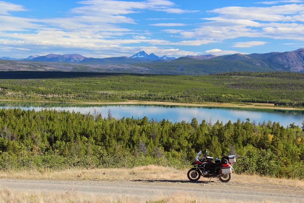
| Choelquoit Lake an the surrounding country... WOW!! |


 |
| Click on this picture for a beautiful panorama |
Eventually, I decided that I should
be moving on. Any hopes of arriving at the campground farther south along
Chilko Lake that evening were fading fast. I kept riding towards Chilko lake
and came upon a handful of natives fishing for salmon. They convinced me to turn
around. They repeated what I heard earlier… “The road is rough and I would arrive
long after dark”. I check my maps and attempted to ride along the Chilko river
back to hwy 20, eventually camping at Bull Canyon. My plan was short lived as
the road I was to take, was closed due to a slide. Darn it!!! I was shunned
again. I was pretty tired by this time and started heading back to Tatla lake. I came across a turnoff to Cochin Lake. I see
a beautiful campsite next to the lake. For the 2nd camp on the trip.
I share a campground with others. I had a very relaxing dinner with the songs
of Loons and a visit by a lone otter. It was the coldest night of the trip. I
curled up in in my sleeping bag with my tent flap open with fantastic lake
views. I fade off to sleep, my head filled with cobwebs and pleasant thoughts
about the past couple of days.
 |
| Another fantastic day comes to a close |
Stay tuned for Day 6
What a coincidence! A fellow rider and I were just talking about this area while discussing our route to Alaska next summer. Nice write-up and photos!
ReplyDeleteHey, I enjoy your site but won't be commenting again.
ReplyDeleteThe red tape of having to type in a (very tough to read) word or two to prove I'm not a robot is too much for these old eyes!
Just thought I'd let you know.
Good site!
Hey there Grizzlee! Thank you so much for sharing this post, full of clear, bright, colourful photos and words of your Chilcotin adventures in that high, wild, wide open country. It's nuts that I still haven't ventured up there yet but you helped inspire me.
ReplyDelete