An All (mostly) Dirt Route from Clearwater BC to the Bowron Lakes Gold Country ...
Read
Part 2 here
Trip Summary
High Level Route Description
Snohomish to Green Lake BC then over to Clearwater to Mahood Lake, to Canim Lake, to Elbow Lake, to Crooked Lake (and a hundred other lakes in between, not to mention all the rivers, streams and creeks), to Horsefly, to Likely, to Bowron Lakes, then back to Likely, to Quesnel Forks (Ghost Town), to Horsefly, to Williams Lake, to Gang Ranch, To Alkai Lake, Kelly, Lake, Pavillion, Lillooet, Texas Creek Road to Lytton and finally the Nicomen Road to Boston Bar and finally back home.
I covered a total of 1500 miles ... Over 1000 miles of dirt! Dirt is in every nook and cranny on the bike, luggage, camera... Heck, I've got dirt in parts of my body I didn't know could get dirt. I've met wild women (yes, a mountain guide living out in the bush by herself .. makes great pizza BTW), young hipsters in broken down cars, old farts in trucks, many natives, 7 bears, baby bob cats, 1 moose, 150 suicide squirrels and chipmunks, drank numerous beers of all kinds, ate candy bars, nuts, dehydrated food, bathed in a couple of rivers, survived a hail storm, met my friends (Alex and Jenny) coming back from the Yukon via moto bikes, passed two world famous bike travelers (Simon and Lisa .. on their way to Alaska on their new BMW GS's), etc.
I had to buy a new map... wore the other one out and/or used pages of it for butt wipe. The "BC Back Roads Mapbook of Lies" ("Isn't there supposed to be road here?" is the question I find my self asking over and over again. ). Awe yes, that's all part of the adventure. U-Turns included in the total mileage count... Sigh?!
////////////////////////////////////
 |
| Mission to Hope via Harrison Mills |
 |
| Lost in No Man's Land |
 |
| Mtn Sheep at Spences Bridge.. note turbulent skies. |
 |
| More Sheep |
Arriving at Spences Bridge, I encounter a slight traffic
jam. But all is cool as folks are slowing down and/or pulling over to view the
mountain sheep on the side of the road.
Shortly thereafter I encountered a heavy dose of rain,
complete with hail intermixed. No worries, as the temps quickly dropped to 70
deg within minutes. I was pretty miserable riding in 97 degree heat and the
rain/hail mix felt wonderful.
Beyond Cache Creek and Clinton, I was passed by Lisa and
Simon of
2RideTheWorld fame. And then
soon after that I had a chance meetup with my good friends, Alex and Jenny. They
were returning from a motorbike trip in the Yukon. It was a strange coincidence
to meet all these familiar folks out in the middle of nowhere.
 |
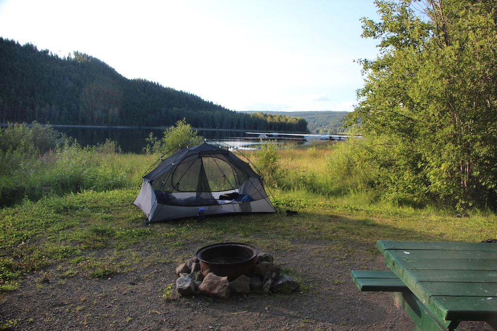
| Camp at Green Lake |
I continued on and camped at Green Lake Provincial Park
(Sunset View Campground). It was virtually full. I hadn’t realized that this
was BC Day weekend. The first Monday of August is known as British Columbia
Day (BC Day) in the province of British Columbia. It is a holiday
giving BC Canadians a chance to celebrate their achievements or relax with
friends and family members.
Luckily, I got the last available spot. It was now hot and
muggy around 8:00 in the evening. I was feeling a bit sluggish. I had some dinner
and crawled into bed and read my book until my closed for the night.
 |
| One of many lakes I pass along the way to Clearwater B.C. |
 |
| Countryside views like this were common up to Bridge Lake |
The next morning, my real adventure began as I was to cover territory
I had never seen. I was to head over to Little Fort and then to Clearwater, hoping
to make it to Mahood Lake by Day’s end.
The Park Facilitator Operator came by to wish me safe travels and
told me about a great little detour down to Little Fort. Eakins Creek Road was the original road that dropped down the pass to Little Fort. She said it was scenic and very doable on my bike. It also passed through a protected area following Eakins Creek (duh). So off I went, riding a dirt route out to Bridge Lake. I briefly touched pavement on Hwy 24 and then turned
onto Eakin Creek road just shortly after Emar Lakes Provincial Park. It's a beautiful little
dirt route to Little Fort. All big bike friendly and I didn’t see another soul
out there.
 |
| Lunch and a much needed break at Coldscaur Lakes rec Area |
I arrived at Clearwater and purchased a new BC Back Roads
Mapbook of lies. My old one was dog eared, torn and missing pages. It also had
many remarks and notes in it from my various travels up in central BC. My goal
was to have a more up to date book with updated roads and such. My old one was
already 15 years old and I had many profanities scribbled down within it's pages... mainly form my Chilcootin expeditions. The truth be known, it didn’t really help much. Some of
the road data was inaccurate or didn’t show all the roads in I needed to make
my way over to Bowron Lakes via all back roads, skirting the Cariboo Mountains.
 |
| Scenic Mahood Lake and showers :-( |
I took Camp Road 2 up towards Coldscaur Lakes. At some point
the name of the road changed and numerous side roads began appearing. Many
looked like major trunk lines. Many were not on the map, nor on my GPS
(sigh?!). What I found was a couple of signs along the way, in the overgrown
bush pointing the way to Mahood Lake. I was suspicious as it appeared to go a
direction that was not in line with the map direction. I ended up crossing a
few private farms, ranches and 1
st Nations lands. Eventually the
roads appeared on my GPS and seem to line up well when I got towards Mahood
Lake.
 |
| Selfie |
 |
| Dream home at Canim Lake |
I rode around Mahood Lake, hoping to maybe camp there for
the night, but it began to shower, and I decided that I could just continue to
Canim Lake and maybe find a cabin to hole up in. The good news was that the
further I got away from the Cariboo Mountains, the better the weather got and
soon, I found myself in glorious sunshine on the shores of Canim Lake. I ended
up staying at the Canim Lake Resort Campground. They had hot showers, a hot tub
and there was nice general store across the road to get some goodies… like
beer. I actually split a six pack of “something” called beer (sorry, I am not
familiar with Canadian brands) with my camp neighbors.
 |
| Camp at Canim Lake Resort |
The next morning I took off towards Horsefly. My
destination for the day was to be Likely and maybe explore the Ghost town known
as Quensel Forks.
So I took off heading up the Canim/Hendrix Lake Road. This
road was actually marked pretty well on my GPS and I only had to stop a couple
of times to verify that I was on route. Along the way I passed several little
lakes, ponds and creeks. The sun was shining and all was good with the world.
 |
| Elbow Lake |
Eventually I could see a sizable lake through the trees
and my map say it was Bosk Lake. Bosk Lake looked very interesting. I was
looking for a way to get to the shore and have a look. At the west end there
was river and a rec site. There was a cardboard sign on the rec site sign that
was written in marker stating that it was full. I pulled in anyway. Yes indeed.
It was full. Wall-to-wall campers. I couldn’t get to the lake front without
walking through peoples camps. At this point I was still ignorant to the fact
that it was BC Days. After a quick look around, I took off and down the lonely road and only saw a pickup
or two along the way. It was very lonely.
I came to several forks in the road, but the main trunk line
road I was looking for was the Black Creek Road. Again I came upon a nice lake
called Elbow Lake and ambled my way towards the shore via a rec site road. Once
again, wall-to-wall people. DAMN!! This was more crowded than the campgrounds in the states. The rest
of the shoreline on the lake was clear. It seems that all these lakes have a
small rec site and no other access to the lake shore. All this country and no
access?!?! Why?. No worries. I was on a mission. I began to worry now if I would be able
to find a campsite at Likely.
 |
| McKinley Lake |
I then proceeded to head out the McKinley Trail Road. And
then BAM!!! The road was closed only a mile or so from it joining the Black
Creek Road. The sign stated that the Bridge was out. I looked at my map and
there appeared to be a faint road up to the Black Creek Rd on the McKinley Lake
Road. So off I went, I soon discovered the supposed road was a quad/horse
trail. I ran into a dead end at McKinley Lake. Again, it was multi-family
affair at the tiny rec site. Hardly any room to turn my bike around. I asked
the campers about options and they told me I had to go back quite a ways to
Crooked Lake and then I could catch the Black Creek Road from there.
So off I went, backtracking several miles of dusty, gravel roads.
 |
| Crooked Lake |
I soon realized what the orange signs I saw
along the road and at each intersection meant now. They all said "McKinley Lake
Detour"… So much for taking my time. I was now worried about arriving in Likely
after dark. But it wasn’t a big deal. I found my way to Crooked Lake and was
quite happy. It was a large lake that nestled up in foothills of the Cariboo
mountians. I could see glaciers and snow off in the distance. It was a great place
to have a late lunch. AND!! NO ONE was camped at the rec site. I had it all too
myself. What? I was confused.
 |
| Crooked Lake Rec Site |
After a lunch I headed towards Horsefly. I was curious as to what Horsefly was like. Having traveled hwy 97 in Canada numerous times, I’ve seen turnoffs for Horsefly near Williams Lake. The name sounds intriguing. But first I would have to get there. The route now dictated that I take Black Creek road to Horsefly. The road was wide and well graded. I was able to keep a steady 50 mph plus pace for most of it … albeit a bit dusty. I was hoping to see a town called Black Creek that was called out on my map and GPS. However, when I got to where the town was supposed to be there was a ranch called Black Creek … and nothing else.
 |
| Lots of these signs everywhere |
I noted a consistent pattern regarding wilderness FS roads. My map and my GPS noted gaps in these areas whenever I saw a "Wilderness FS Road" sign. This made it tough to plan my route.
 |
| Quesnel Lake... HUGE! 70 miles loooong. |
From Black Creek, I made it to Horsefly, crossing the one lane bridge
into town. I stopped at Fast Gas to fill up … My GS prefers premium fuel
… you not find anything more than regular unleaded and diesel out in
these parts. No worries. I’ve filled up before with regular. It all
seems to run just fine in my big girl.
I stopped at Clarks
General Store and got some snacks and asked about the route over to
Likely. I was told it was all good roads and I should have no problem.
So off I went. Before heading out, the heat was getting to me. It was
90+ degrees out and I was a bit tired. So I took a brief catnap along
the Horsefly River.
 |
| Remnants of the Polley Mine Disaster |
From there I took the Mitchell Bay Road and
ended up riding parallel to the Horsefly River toward Quesnel Lake. I got
to the Ditch Road and crossed the area washed out from Polley Mine
incident.
 |
| Remediation efforts appear to be going well. |
The Polley Mine disaster involved the breach of a
tailings pond (4 square kms) that released years of slurry into Quesnel Lake in
2014. Hazeltine Creek, which is normally only an arms width in flow was devastated
in the area I rode through. Recent water testing show that the elevated levels
of selenium, arsenic have subsided and the water is now safe for drinking
again.
 |
| This picture is for Lori. She loves Moose. |
 |
| What a scenic place to live. Quesnel Lake in the background |
I arrived in Likely late in the day. I was thoroughly impressed
with Likely and the setting of the community. It is situated on the waterfront
of the Quesnel River. The outflow of Quesnel Lake, which is the largest Lake in
the Cariboo region. It has two arms that go back into the Cariboo mountains
nearly 70 miles. Fortunately the general store was still open. I grabbed a
couple of beers and a snack. I enjoyed the waterfront park immensely, soaking
up the rays of the sun and enjoying the sculpture of the metal man.
 |
| Iron Man in Likely |
 |
| Likely Lodge and Restaurant |
 |
| Main street in Likely is actually more of a river way |
 |
| A couple of six packs and this is what I look like the next day |
 |
| I'm 6'3".. Iron Man is at least 7'3" |
 |
| One lane bridge crossing into Likely |
 |
| View of the Quesnel River from the Bridge |
 |
| Camp at Cedar Point Park |
I spent a very quiet and relaxing night in Cedar Point park, 6km outside of Likely, along Quesnel Lake. I drank a couple of beers and enjoyed the quiet and cool dusk.
 |
| Dinner and beer |
 |
| Stop sign in the Quesnel River?!?! |
 |
| Morning in Likely |
The next morning I went back to Likely to fuel up, grab a cinnamon roll and then proceeded out to Quesnel Forks for breakfast.
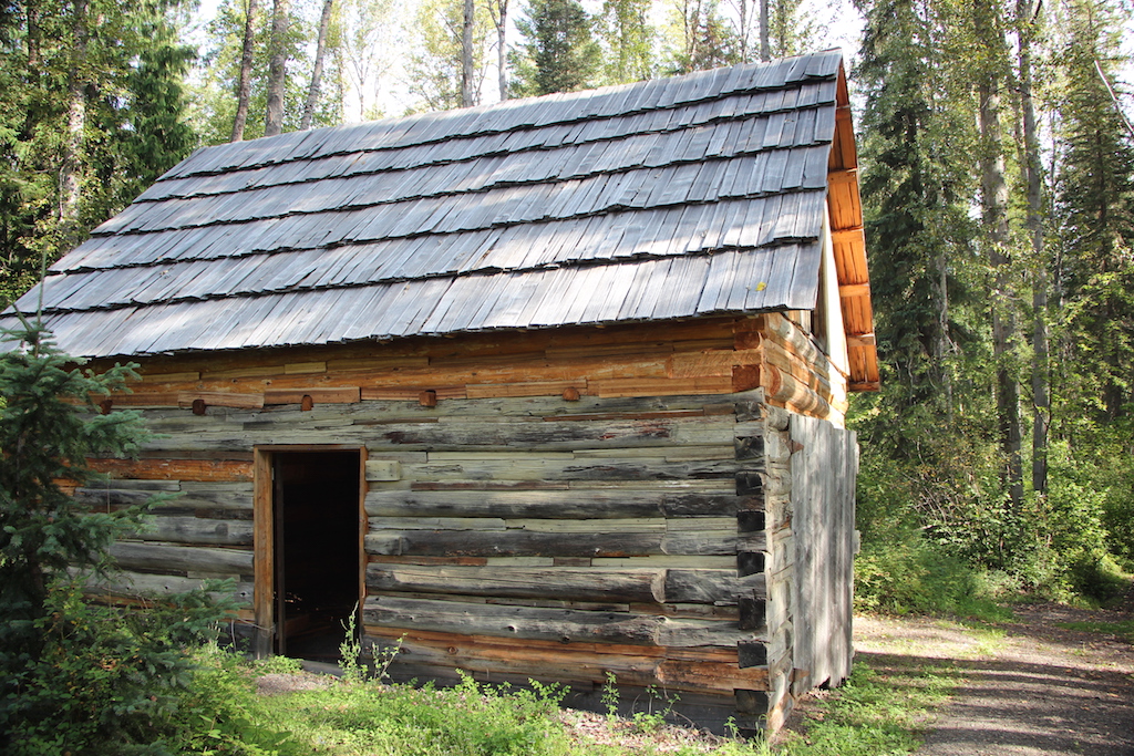
Quesnel forks is a neat little ghost town. It was a gold
rush town formed in 1860. It is
undergoing a bit of restoration by the locals. For the most part, it was
abandoned some years later as gold was discovered up near Barkerville and a
wagon road was built that bypassed Quesnel forks, but a group of Chines miners
and merchants continued to live there for some time. The town was completely
abandoned in the 1950s.
I was the only one there and wandered the town site inspecting the buildings and reading all the historical plaques. I made a note to return to this place. Also, because of the confluence of the Quesnel and Cariboo rivers, it is a natural take out place for people floating the river. Another bucket list item for me.
 |
| Add water and I may have taken a bath here |
 |
| Typical Home |
 |
| Lots of shoes... This may have been a secondary general store |
 |
| Hornets in the outhouse. YIKES!! |
From Quesnel Forks I headed east on Keithley road and eventually crossed the Cariboo River. I could tell that I was following the the Cariboo Lake/River according to my map. However, there was no access and the best I could do was get the occasional glimpse of the lake.
At some point, the FS road I was on veered away from the
western portion of Cariboo Provincial park and I came across another “Wilderness
Road” sign. Of course the GPS and map had a blank spot in this area (sigh?!). I
must say, however, that the road was in fantastic shape and a real joy to ride.
I crossed numerous creeks and rivers on wooden one-lane bridges. The forest
closed in and I felt like I was really getting closer to true wilderness.
It began to get really rocky and at one point I passed
Maeford Lake. Unfortunately, I could only get glimpses of the lake. As it was
nestled in a cirque. The only access I could find was a road that was gated
shut. My GPS indicated some kind of structure there.
 |
| Chocolate Moose Cafe... Really?! Out here in the middle of the wilderness? |
Not too far beyond that the road gained some altitude and
I the trees gave way to rocky outcroppings. I popped out at Cameron Ridge.
Before I knew it, I was upon a place called the Chocolate Moose Café. The sign
stated Pizza and Beer. It also said they were open. I had to check this place
out.
 |
| Wood fired Hot tub in paradise. Yes.. |
 |
| The menu |
Sure enough, there was a restaurant and a couple of gals
baking. I couldn’t believe it. I ordered a pizza and a beer. I could see into the heart of the Cariboo Mountains from there. It was stupendous.
 |
| Pizza, beer and cheesecake... Am I dreaming? |
 |
| The views from the patio |
Aside from the restaurant, they had cabins for rent as
well as a wood fired hot tub. The owner (Chris Franke) also guides people into the back country via horseback (Mountain Spirit Outfitters Inc.). In the winter
months she lives in Likely. What a grand place to live your life.
 |
| The Cariboo Mountains... Heaven |
I stayed and rested for over an hour, just soaking up the
views. Another gent showed up, looking to take a shower and have a meal. Turns
out he was a prospector and we chatted a bit about mining in this country.
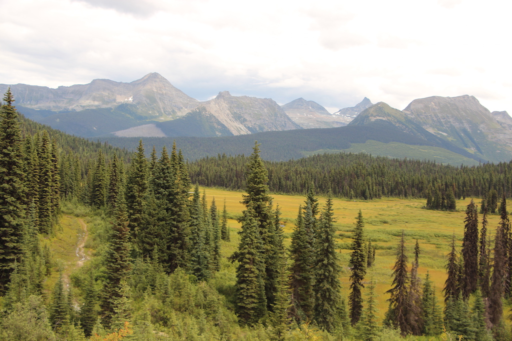
The views form Cameron ridge were spectacular to say the
least. I could only imagine that the views across the valley towards the Cariboo
mountains would offer opportunities for some great wildlife viewing.
BTW:
Showers cost $5. I had bathed in the Quesnel River the night before, so I was
good
:-)
 |
| Falls on the way to Ghost Lake |
After enjoying the company and the pizza from Cameron
Ridge. It was time to head out to my next destination, Ghost Lake. Ghost Lake
is located at the edge of the Cariboo Mountains Provincial Park. Along the way
to Ghost Lake, the road got very interesting. I found myself dodging bear scat
like a tank driving through a mine field. The bush closed in around me and I
saw 2 big black bears ambling down the road at two different times.
 |
| More falls |
There are 2 spectacular falls to see at Ghost Lake. As
the Matthew River exits this spectacular narrow valley, there is a bridge where
the road winds its way up towards Ghost Lake. From this vantage, there are some
pretty awesome views looking down the cascading falls into the valley below.
Following the road higher up and I arrived at a
campground(?). There were only 2 camp slots and it was infested with BUGS!!! I quickly took off my riding boots and put my
trail runners on and pulled a mosquito
net over my head as I headed down a trail to Ghost Lake.
 |
| Ghost Falls... WOW! |
Once at the edge of the lake I was a bit disappointed as
the cove I was in, didn’t allow for any views up the lake. I found myself
winding around trying to get better views. In doing so, I found myself at the
top of Ghost Falls. WOW!!! Still no views up the lake, but the falls made a
thundering sound, vibrating the ground. I now had to gain a better vantage point. I climbed up and
around in the bush, only to discover that I was back at the parking
lot/campground. I found a little trail that led to a nice vista of the falls.
Still no views up the lake. It looks like I will have to come back with a canoe
or kayak to get up to the other end. I did notice an abundance of blueberries.
It became clear to me why I was seeing so much bear scat. This was not an area
to have a surprise run in with a bear. I purposely made lots of noise as I made
my way back to my bike.
 |
| Looking back into one the valleys of Cariboo mtns |
 |
| Roadside views were so cool and scenic |
 |
| Baby Bobcats |
I made my way to Barkerville. Along the way, dark clouds quickly formed and it began raining profusely. This is a common occurrence in this area as it is an inland rain forest. I attempted to head over to Bowron Lakes, but the road was like grease with the calcium chloride on the road in the rain. So I turned around and decided to head over to Quesnel for the night and clean up. I did see a mother bobcat herding her 3 babies through the woods near the town of Wells. It was pretty neat as I have never baby kits before. They wanted to investigate the man on the motorcycle, but mom made sure they stayed away and swayed them to follow her into the woods.


I'm a Williams Lake resident and this area is one of our playgrounds. After you passed Maeford lake you would have crossed a small bridge and then climbed a bit of a hill and to your left would be Grizzly lake and a little ways up from that around the 42-45 km mark on the road the start to the Cameron Ridge trail takes off to the right. There is a quad/motorcycle trail that is ribboned that takes you to the top of the ridge around 6500' with tremendous views of the very end of the north arm of Quesnel lake and massive glaciated mountains across the lake and up the Mitchel and Penfold valleys, just a note though this area can hold snow into late June through mid July so if you ever decide to check it out pick your date for later July or August.
ReplyDeleteThanks for the info. You are fortunate to have this in your backyard. I can only imagine how beautiful those views would be. I would love to see the north end of quesnel lake. Much appreciate the info.
ReplyDelete