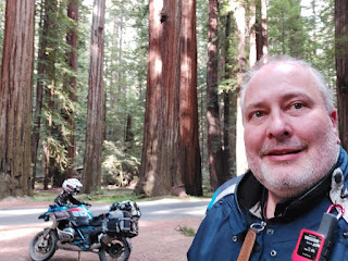
Nice Moto Trip from my home in Arlington, Wa to the Califonia Lost Coast and beyond.
 |
| Waiting for the Kingston Ferry in Washington. |
 |
| My good friend Bruce and I enjoying Dinner at Hoodsport Burgers, Teriyaki and Ice Cream Before we get to camp |
 |
| The next day, Bruce and I take a tour through the Capital Forest State lands south of Olympia. |
 |
| On our way to Brooklyn we pass through the Chehalis tribal lands and pop out on teh Wa coast by Raymond, Wa |
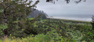 |
| Near Cap Disappointment we found a pullout that had great views of Beard's Hollow. |
Beards Hollow is located at Cape Disappointment on the Washington Coast, south of Seaview, Washington, and north of the North Head Lighthouse. On November 15, 1805, Captain Lewis reached the Pacific Ocean near Beards Hollow. Beards Hollow was named after Captain E.N. Beard whose ship, the bark Vandalia, met disaster off the mouth of the Columbia River in 1853. The crew was lost and Captain Beard's body was found on the beach near the hollow.
 |
| Cape Disappointment Light House. |
Cape Disappointment is a very notable place. By the time Lewis and Clark
reached the site in November 1805 it had already been named. The first
known documentation of the site was in 1775 by Spanish explorer Bruno
Heceta, who named it the Bay of the Assumption. Then in 1788, British
trader John Meares named it “Cape Disappointment” when he mistakenly
believed that the mouth of the Columbia River was only a bay.
Meriwether Lewis laid eyes on the area in mid-November 1805 – he
proceeded on by land while the rest of the Expedition sheltered at
Dismal Nitch. He returned to camp on November 17 and Patrick Gass wrote
in his journal, “They had been round the bay, and seen where white
people had been in the course of the summer; but they had all sailed
away.” For this reason, Cape Disappointment had a different, unhappy
meaning to the men of the Corps.
 |
| This is the big haystack rock at Cannon beach. An iconic sight along the Oregon Coast. |
 | |
|
 |
| The next day, Bruce and I parted ways. I spent the night in Newhalem Bay State Park. |
 |
| Stove mishap |
Mishap at Camp. I mistakenly forgot to take the plastic ring protector off my jet boil pot. I set it on the jet boil and it immediately melted. Not only did it melt my protective cover, that served as a plate, but the stove itself melted. The supports are plastic. The next morning, I spent a over an hour or so in Tillamook looking for a new stove. Being a Sunday morning, not much was open. I found Tillamook Sporting goods store was open and they had only one Jet Boil left in stock. I bought it, but found out later that it wasn't the same as my old stove. My old stove had an igniter and a variable burner control, This replacement was a full on or off. Designed to do one thing and that is to boil water fast. No worries, it wasn't going to spoil my trip and I did get a replacement burner later from REI that had all the features I wanted.
 |
| For the most part, it was foggy, wet and cold on the Oregon coast. I really didn't get to see and enjoy it as much I wished. |
 |
| Hecta Head Lighthouse |
I did get to see Hecta Head Light House from a distance as there was a break in the foggy mist. This picture doesn't do the view justice. There is a beautiful cove where the keepers house and such are located. It is a must stop and see place on the coast. If you are in a hurry like me (limited vacation), you cannot fully savor the experience. Fortunately, I have been here many times. However, I was still saddened by the lack of good weather as this is part of what I came to enjoy.
 |
| Here is a digital zoom pic of the light house and the bay. |
 | ||||
As mentioned, these were about the best kinds of views I could muster on
this day as it was cold and wet all the way to Coos Bay.
|

 |
| Yes, All Dogs Matter |
I walked back to the motel in the rain. Being the dog lover I am ( we have a golden retriever puppy AND a side car.. more on that in other trips), I got a good chuckle out of this sticker. It has been a tough year politically and I was glad to see someone found humor in it. Off to bed I went, but not before, I reviewed my maps and chatted with my wife to let her know I was ok and having fun.
The next day I left Coos Bay with a dreary overcast sky. I took Hwy 42 over to Couquille. Which was the original route of the hwy101. It was originally veering, inland bypassing a big stretch of the coast and originally cam out at Bandon, Oregon. I took a turn right on to hwy 542 just past the Hoffman State Wayside memorial. I had an enjoyable ride out to Powers. Powers is a quaint little community of about 1000 people. It is a great place to visit. Heading south beyond powers the road turns into NF-33 and the scenery takes a turn. A a narrow paved road goes through a green canopy of forest groves. There are numerous campgrounds... all of them good. The South Fork of the Coquille parallels the road until you reach a pass. I did not take any pictures of this section, but my video gives one a good idea of what to expect. It is really beautiful. At some point NF-33 branches to the right to become NF3340. I stayed left and continued on NF-33 which is also known as Agness Rd. Agness is another tiny community that is located in valley on the Rogue river. At this point the road turned to gravel and I was up at a much higher elevation and got soem fantastic views of the Rogue Valley to the north east. This is an area I must return to as it is spectacular and, I believe, a hidden gem.
 |
| Travel on Agness Road |
 |
| I make a stop to enjoy the views and fly my drone |
 |
| Beyond Agness I follow the Rogue River to Gold Beach |
After I pass by the turnoff to Agness, I am at the valley floor and run parallel to the Rogue River. The ride is fantastic as I roll through a green canopy withe views of the Rogue River never far. It took me much longer to travese this route than I thought. As result, I knew wasn't going to make it to the California Redwoods that day. At Lobster Creek, the road was now called Jeery's Flat Rd. Not far to go until I got to the Coast and the hamlet of Gold Beach. I got some food and gassed up and headed south on hwy 101 to the Pistol River Area.
Unfortunately, I was filming more that taking pictures through this stretch of the coast. However, I got it all on video and I can say that I really find this part of the Oregon Coast from Gold Beach to Brookings to be my favorite section.
 |
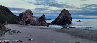
| Pistol River Area |
I was now hoping that Harris Beach State Park would have a slot for me , my bike and my tent. To my surprise, they did. Harris Beach is a wonderful place to camp as the shoreline there is spectacular.
I setup camp and then made dinner on the beach and enjoyed the sunset.The beauty of the beach speak for itself in these pictures as I enjoyed a blue sky and a quietness broken only by the sounds of the surf and the occasional gull.
 |
| Harris Beach |
 |
| Yep, that's me |
 |
| Nice beach hike for sure |
 |
| A big island rock |
The next day I had a nice breakfast in camp and took a spin down to the beach and enjoyed a cup of coffee while enjoying the views that Harris Beach has to offer.
 |
| Morning view of Harris Beach |
Soon I crossed the border into California. Just before Crescent City there is a turn onto a spur highway, Hwy 197, that joins the Redwood highway, as I wanted to tour of Jedidiah State park. Crossing a covered bridge on the Smith River (Near the Myrtle Beach turnoff), there is a narrow dirt road that passes through the Stout Grove, the Grove of the Titans, Boy Scout Tree, etc.. It is a wonderful ride through some Redwood giants. However when I arrived, the I was great by a park ranger with a gate closer. They were making repairs on the road. This was unfortunate as this is one the gems of the Redwoods that is perfect for a ride.
 |
| Hwy 199 the Redwood Highway |
 | ||||
| Every motorcycle rider should ad this road to their bucket list. | |
 |
| Just south of Crescent City on hwy 101 there is a wayside pullout |
 |
| Views back north to Crescent City |
 |
| At this point Hwy 101 begins it's coastal tour through the Redwoods |
 |
| I made a stop at the Trees of Mystery |
 |
| Paul Bunyan and Babe the Blue Ox. |
Trees of Mystery is a worthy stop, even if you don't take the touristy tour. The gift shop and parking lot are worth it. I had a snack here and enjoyed the Disney-like atmosphere. At one point, I was alone with Paul and Babe (Paul Bunyan is 25 feet tall and both he and Babe are clearly visible form Hwy 101 to lure unsuspecting tourists). They must have cameras, as I soon found myself in a discussion with Paul (through a speaker) and whomever was controlling the giant figure was giving me a friendly wave through Pauls' articulated hand. Although I have been here many times, I have never actually taken the interpretative trail tour and apparently there is a sky tram that takes guest up in the air through the tress and to a observation deck where one can see the ocean. Notably is the Cathedral Tree, a grove of 9 trees in a semi-circle where many weddings are held. I would like to return and take the tour with my wife.
I then took the Prairie Creek scenic dirve (aka Newton B. Drury Scenic Parkway) to the Elk Prairie area.I highly recommend this side ride as it is scenic and slower than hay 101. There, near the campground was a herd of Elk.
 |
| Newton B. Drury Scenic Parkway and big trees.. very scenic |
 |
| Elk Prairie and complementary Elk Herd. |
Soon after I took a side tour that took me on an old section of the
coastal highway that passes by some freshwater lagoons. I found it
interesting, but not much scenery that was a must see.
I soon found myself in Eureka with high winds and lots of traffic!!
Finding a place to get lunch in the pandemic world was tough as I had to eat outside and most places were closed to seating. However, all was forgotten when I made the departure from hwy 101, just
before Fortuna on my way to the small hamlet of Ferndale.
 |
| Classic Architecture in downtown Ferndale (wish I had taken more photos) |
 |
| Off to the beach at the start of Mattole Road in Ferndale |
Leaving Ferndale, the road can become a challenge. Mattole Road winds it way up the coastal range on broken asphalt, gravel, narrow roads and tight turns.
To really appreciate the Mattole road, I refer readers to the video. It is a spectacular ride going up and over hills and small mountains with great vies to the lower valleys and even the ocean.
Making time on this section over to Petrolia is not an option and those who do rush it, will miss some of the best parts that the Lost Coast has to offer.
 |
| Mattole Road |
Initially climbing up to nearly 1600 ft, the road winds it way down and crosses the Bear River.
This is some of the best parts of the Humbolt area. Large farms and ranches are dotted throughout this area.
 |
| Looking down into Capetown where the Bear River Flows |
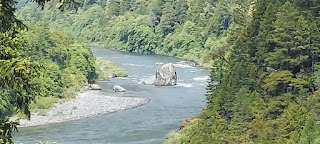
The northernmost access to the beach is at a black sand beach next to a steel bridge close to Steamboat Rock, which looks like a ship from the shore. In between there are various pull-out spots where you can find a way to the shore.
 |
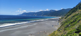
| Off to an area called black sands beach area |
 |
| Windy, but beautiful and surprisingly remote |
 |
| This region has the longest stretch of undeveloped coastline in the lower 48 states. |
 |
| Rock formation looks like a battle frigate |
Afterwords I climb back up and go inland a spell. It ride through the small village of Petrolia. Petrolia is remote and small, with an estimated population of 300-500 people within a 15-mile radius.
Petrolia's isolation is due to its position on the rocky, treacherous coastline.
 | ||
My Camp at Mattole Campground. The beach is about 100 yards away.
|

 |
| Wonder what kind of tree this was? |

 |
| I'm not alone |
I am surprised that all this exists in here in the golden state of California. Indeed, this must be some of the loneliest lands in California. I read a review that has called this area "too lovely to be believed, perhaps too beautiful to last.". Let's keep it wild.
The next day I had a casual walk down the beach and ran into some hikers doing the Lost Coast Trail. This is a really cool hike that I'd like to do someday.
 |
| This was to be my route for the day. Not a big day distance wise. But believe me... it was a BIG DAY! |
Unfortunately, I don't have many photos from this day. Seems like everything I did was on video.
However, here are some scenes from my morning camp. A bit breezy and chilly. But very enjoyable.
 | ||||
| My morning camp |
 |
Explaining how I melted my stove |
 | ||||
| Leaving Mattole beach and heading over to Shelter Cove | . |
 |
| A unique feature at Honeydew. The truss bridge spanning the Mattole River |
I’m heading to a town that is supposedly cursed from, the days of
Spanish and Russian explorers, the killing of local ingenious people,
shipwrecks and plane wrecks and drownings.
A place with a
general store, two fuel pumps and an aging airstrip where I have to
cross a remote and largely undeveloped swath of land with steep forested
mountains that dip down into the sea.
A place where highway builders gave up long ago and forged roads inland.
This place, Shelter Cove, has transformed from a sheep ranch to a fishing village and now to a “resort-town-in-waiting”.
With all that stated, it is a FANTASTIC ride and one I highly recommend.
 |
| Black Sands Beach at Shelter Cove. This is where all the hikers usually exit. |
No other photos of Shelter Cove. I really don't know why. Trust me, Shelter Cove is a cool place that you will want to visit. The lighthouse at Shelter Cove (used to be located at Cape Mendicino) is perhaps the most famous landmark and a tourist attraction. The beach by the lighthouse is very nice and worth a visit. The campground there looked to be a worthy place to stay. And someday, I just might.
Leaving Shelter Cove, it is 24 miles along the Briceland Road to Redway and then out to Highway 101 onto the “Avenue of the Giants”. This is perhaps the best maintained road in the Lost Coast. However, it comes with many surprises. Tight curves will creep up on you, and the scenery will keep one’s head spinning in wonder as the trees, rivers and green canopy can easily swallow a motorcycle and distract an awestruck tourist.
 |
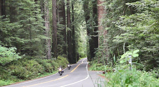
| "Avenue of the Giants". A must see by whatever means... car, bike, skateboard or foot. Don't delay. |
Avenue of the Giants has been called the finest forest drive in the world. No argument from me. I have driven by this area a couple of times in my life. Trust me when I say that I am sooo sorry I did. Don't do what I did. Go and see it.
 |
| Look up and you'll be hard pressed to see the sun with all the canopy... |
 |
| Meeting other GS riders on the "Avenue" |
Giant trees line a 31-mile Avenue parallel to Highway 101. It’s flat with gentle curves, passing through secluded forest hamlets, campgrounds, picnic areas, and the Eel River.
Numerous memorial groves and trailheads can be found along the avenue, each leading into the magical redwood forest.
 |
| I feel small and humble in this land |
 |
| Too ride among the trees is an honor |
 | ||||
| Ashes and flowers |
I made a rando stop to have a snack and took a walk through the woods to get engulfed by the trees away from the road. I noticed a really "huge" tree, and decided to walk up to it. As I was walking around it, I found some flowers and ashes. It was a humbling moment and a beautiful place to have ones remains spread.
 |
| Looking up... A sentinel, a guardian and protector of the forest. |
 |
| A hike of the bike. One quickly disappears into the canopy. |
It is a dream ride, not to be missed and a worthy addition to any motorcycle bucket list destination.

I spent the night in Arcata. As I arrived late, I got a motel at the Red Roof Inn. In hindsight, I should've found a place to camp in the Redwoods, as I had a miserable experience that night. After I checked in and got some dinner, I was surprised to see alot of homeless folks around the area come out of the woodwork... so to speak. One point in the night I got up to look out the window and saw a young gal with a dog in a dog carrier sitting right next to my bike. I had my biked covered but was concerned as a couple of folks turned up to park in the stall and saw her and her dog sitting on the curb and parked elsewhere. Her dog carrier was sitting in the parking stall. I kept an eye on her and all the musings of the homeless people coming and going across the street. At one point a car pulled up across the street and a mass of homeless people gathered around it. It appeared to me like some sort of business deals going on. The car appeared to be loaded with clothes and other stuff(?!?) I was too far away o exactly what and the swarm of people made it hard to witness the transactions. The crowd dispersed fast after the police showed up. I noticed the police cuff the gent in the car and they left it parked. Only after the police left, many folks would come up and attempt to open the doors. Drugs...? Hmmm.?
In any event, back to the gal and the dog in the motel parking lot. I noticed the gal began to start removing my bike cover. Being waterproof and such I suspect she thought it may make a good tent/shelter/blanket. I quickly went to the lobby and asked for the police. The lobby person suggested I go out and talk to them. WTH!?!? I dialed 911 and a unit appeared immediately. The police talked to the gal and waited until she walked off and down the street away. During this time, someone pulled in to the parking slot next to my bike and I was relieved a bit. Needless to say, I will never stay in Arcata again and this experience has made me suspicious of Eureka and Crescent city. Being from the Seattle area, I know all to well about the homeless issues. I was surprised to find such problems here. I guess I am a bit naive. I found this on this statement about the homeless problem in Eureka.
"Previously the center of the logging and timber industry, time, wear and a declining economy has plunged Eureka into an epicenter of poverty, drug addiction and mental illness. The result was one of the worst per capita homeless problems in the nation. Eureka has had a severe homeless problem for more than 30 years."
In any event, not a good night's rest, but I did mange some laundry and grabbed some breakfast grub before heading out of town. My next move... Ride Bald Hills Road over to the Bigfoot Scenic Byway.
 |
| My Route for the Day |
 |
| Chilling in the sun at a freshwater lagoon off the ocean. |
My stop into the Redwoods Visitor Center at Orick, California Gateway to Redwood National Park yielded this notice when I was searching for Bald Hills road.
Notice from Redwood Parks Website:
YOUR GPS IS WRONG. Alert, Severity, caution,
DO NOT use "BALD HILLS ROAD" to drive to Redwood National Park. Most digital maps and apps (yes, including the one you love) do not have accurate information in this area.
YEAH, A CHANCE TO GET LOST!
A quick chat with visitor staff confirmed my chosen route. I was good.
 |
| Redwood Creek Overlook. |
I had a quick stop in at the Lady Bird Johnson Grove, but I was in a "seen that, did that" type of mood from my experiences over the past couple of days. I really wanted to get on top of Bald Hills road and see what all the fuss was about. My little brother, who also rides, told me this was a must see road. A road that was closed to my wife and I year earlier due to covid and native road closures as we were coming from the Highway 96 down from Happy Camp.
The Redwood Creek Overlook was definitely worth a stop. One could see out to the ocena form this vantage point.
 |
| Great descriptions of the surroundings and very educational. |
And then there was Bald Hills Road... Fantastic ride all the way.
 |
| Bald Hills Road: Green meadows |
 |
| Bald Hills Road: A dream road to ride on |
At 31.7 miles long, the Bald Hills road is mixture of pavement and gravel running west-east from U.S. 101 to Hwy 169.
In addition, there many vistas, possible elk viewing, views out to the ocean, magnificent oak woodlands and prairies to explore. I experienced a ridge line lined with Alpin Lupin in full bloom and the miles of green meadows and thick forested areas off in the distance.
Along the way I pass by Schoolhouse Peak and Lyons Ranch. This is an area where the pavement ended and I was under the impression that I may be way the road would be all the way to highway 96.
However, as the road begins a steady descent into valley of the Klamath River on a nice paved stretch of road as I dove deep into the coastal mountains and arrived at the Yurok Nation Tribal Cemetery.
 |
| Be careful on this stretch. Steep twisties down to the Klamath |
From here it is a relaxing, twisty road to the Klamath River.
Don't rush it, rather savor the ride down.
 |
| Rain on hwy 96 |
As I approached the bottom of the Klamath River, the threat of rain is overwhelming.
I get a splash of rain. Fortunately for me, it appeared that I was on the back end of a storm front that had just rolled through.
Lucky Me!
Just to be safe however, I decided to pull off into Aikens Creek campground and hide underneath the canopy of some trees. It soon quite spitting rain and I was on my way.
I stopped in a village called Orleans and topped off my gas tank. I talked with a local about the weather forecast and they stated that I just missed a wicked hailstorm. Again, lucky me!
The sun was coming out in full force now and I the area looked like it just had a nice refreshing bath.
 |
| The Klamath River in the sun |
 |
| The views along hwy 96 are stupendous. |
I continued on my journey to Somes bar. As I was riding and enjoying the ride, I recalled a prior trip up to Happy Camp where I saw an ominous Bigfoot sculpture. I was thinking how, as a kid , I was fascinated with the mythical legend and stories.
I also recalled the story of Ishi, the last known Native American who lived in isolation in this area. He is more famously known as the last wild Indian in North America as he walked out of the woods in the early part of the 1900s into a modern world. Would be interesting to know his thoughts and experiences within the mountains of Northern California. Did he know of Bigfoot? Was Bigfoot a band of natives to live in these parts... All a mystery and adds much to think about as I ride through this wonderful country.
 |
| Bigfoot Sculpture at Happy Camp |
In any event, Highway 96 is often referred to as the “Bigfoot Scenic Byway”. It is a National scenic byway. However, those hoping to see hairy bipedal creatures may be a century too late.
But it’s a nice ride and any chance to see native wildlife whether it be mythical or real is an added incentive.
I like to think that there's always a chance to see something extraordinary
As I came to the turn off on Somes Bar, I was really giddy with excitement. I felt like I was traveling into the land of the lost. The canyon walls became narrow and the stripped 2 lane road became a single paved road that was in need of repair. The road was carved into steep canyon walls.
The gentle twisties become tighter and the road begins to show signs of disrepair as I go deeper into the mountains.
 |
| Looking more like Himalayan country |
 |
| The Salomon River flows through here |
I crossed the Salmon River Bridge and found myself on the other side of the canyon. It was now more of a deep narrow gorge. I stooped several times along the way to fly my drone as the scenery was just too good to be true.
It was getting near time to setup camp and the sunlight was getting scarce in the gorge because of the depth.
I passed by a couple of campgrounds, but looked and my GPS and thought it would be great to get in a little deeper and see more as I wasn't sure if the rains would return and I would miss my chance to experience this awesome country as opposed just to riding through it in the rain. Always the gamble we take when riding a bike.
The canyon was quite narrow and after a bit, I was thinking tha maybe I missed my chance to find a level spot to camp for the night.
Luckly, I came upon Nordheimer River Camp Gound. It was like an oasis out here. Lots of camping and NO ONE HERE!!!
As I was looking around, I was approached, seemingly out of nowhere ,by Erik Jefferts, the owner of Lassen Ale works.
He invited me over to join him and several others on bikes at a group camp on the other side of the Nordheim river. He said the magic words, like minded people and BEER! I was in in.
 |
| Fun around the camp fire.. Look up, someone was flying a drone around the campfire. |
 | ||||
| Great time with new friends and campfire and beer. |
 |
| Special thanks to Erik and his moto friends for a fantastic evening |
I went to bed that night with a full belly, beer and the flames of the camp fire dancing thorough my head. I faded off to sleep reliving the magical day over and over in my head until I drifted off to sleep... most likely with a big smile on my face.
The next day strated out as if there was going to be rain. The camp was busy and humming as everyone was prepping to go thier separate ways. One guy back to Montana, a couple of folks heading back to Colorado, yet another heading south to southern California, etc...
I hung around a bit longer and took my time. I was enjoying the quiet time alone.
The next day was a late start day. I dunno what it was, the beer, the good food, the company,etc.. but I slept in. By the time I got up, most folks were either packed or had already left. I sure did enjoy my quiet morning though. Some breakfast and coffee alongside the Salmon river was soo relaxing.
 |
| My view at Breakfast |
I slowly packed up my bike and broke camp. I was eager to see the rest of this river canyon. Having never been here before.
 |
| Forks of the Salmon |
View from the bridge

Almost to Ceciville

Forks of Salmon, California is nestled in between Arcata and Mt. Shasta. "Kind of smack in the middle nowhere"
Actually, it's in the middle of the North and South Fork of the Salmon River, hence the name.
The harsh, natural landscape doesn't exactly make it easy on visitors.
The road scares people away. The one lane is like driving in the
Himalayas... A couple hundred foot drop off to your side. Wintertime
it's icy and downright scary.
The population here barely cracks triple digits as it takes a certain
type of person to withstand the environment around Forks of the Salmon.
I have no idea what this place is called, but it sure is pretty. What a road.


Knownothing Creek is another interesting area. There are several gold
mines in the area as the area is rich in gold quartz. Most of the gold
was extracted before the 1900’s but mining still goes on today.
It’s true treasure however, lies in it's intrinsic remote beauty.
Cecilville was a blur as I wasn't feeling well. Afterwards, I realized I
should have spent more time at the Salmon River Saloon instead of a
quick stop to say hi to some of the crew I spent the previous evening
with.
One unexpected item of note is the frisbee disc golf course here out in the middle of the wilderness.
A return trip is a must.
Unfortunately, I have no pictures of Ceciville and the rest of the day
because of the weather and my demeanor because of the bug I had picked
up. The Video has more description of this in it.
However, not long after Cecilville, the narrow canyon road gave way to a stripped two lane highway.
Gentle twisties should have been fun, but I wasn't feeling well at this point and the wind...
The wind was becoming horrible to manage.
I did stop at the Pacific Crest Trail crossing, but otherwise, I was on a
mission to get over towards Klamath Falls and head north toward home as
the weather was changing fast.
I was spit out at an oldstage stop in Callahan, California. The original
plan was to head over to Mt Shasta via Highway 3. But the wind and
whatever bug I caught was chewing on me pretty badly.
Then there was the threat of rain as there was heavy clouds and lightening in the direction I intended to travel.
I opted to head up to Yreka instead.
And then the rains came down pretty hard. I was getting beat up pretty bad.
I did make it to Kalmath Falls after a cold day in the rain after Yreka.
The next day I was feeling a little better, but not 100%. I did a check
on the weather as I really wanted to detour over to John Day and see the
Painted Hills. The issue was, that it was rainy and windy that way and
even a prediction of snow!
As I left Klamath Falls and arrived in Chemult, the winds were again
very unbearable and I could see lightening in the distance in the NE.
I did a quick course correction and headed up the Williamette Highway
toward Intersate 5. I had to get out of the wind. it was hard to manage
on 2 wheels. Not sure how the truckers and RV manage in this stuff.
Highway 97 has almost been windy whenever I travel there, but this day,
was the worst.Odell Lake, Oregon. Diamond Peak in the background .. A shield volcano.

I arrived at Salt Creek Summit with remnants of snow up at the pass.
One thing I will say, is that I got extremely lucky. A gent and his
GF/Wife/significant other, passed me at warp speed in a sports car and I
soon followed. As I arrived near the summit I slowed down and pulled
over to read my GPS route. Fortunately for me, I did this as a LEO was
parked to setup his radar and gave me a friendly wave. Not sure how the
sports car blew by him w/o gathering attention.
It was a very nice and relaxing ride down the other side of the pass
where I enjoyed lunch at Lookout Lake in warm, soothing sunshine. The
warm calm air was a welcome change to what I experienced on the other
side of the pass.
Lookout Lake


 |
| Lunch and sunshine |
From there it wasn't much too report, save for a long ride home on I-5. I did make great time though.
I arrived in the evening as weather and rain were coming in. I was bushed and looking forward to sleeping in my own bed.
Home at Last

Looks like an awesome time, can't wait to see the videos.
ReplyDelete