This is Part 1 of our experience from hiking the Donjek Route in Kluane Park during a 10 day period from June 27 thru July 6, 2011. There were 3 of us in our party (GrizzLee, Yukon Johann and Bighorn). The experience level of our hiking party was that of experienced backpackers and mountaineers (ages ranged from 15 years old to 46 years old); one of which has mountaineering experience. Members of our party had previously been on long distance treks, including hikes up north in the Yukon and Alaska on trail-less back country, which included trekking in Denali, Tombstone Territorial park and a couple of paddle trips down the Yukon River. This hike was truly the pinnacle of our experiences. It is a very rewarding experience and now a personal favorite. The scenery alone is overwhelming. Words and pictures cannot capture the emotional experience. It is a hard hike and physically challenging. But more than that, it was also a mental challenge and a real test of personal fortitude.
From the Kluane Park Service:
Note: A route is not a trail. Routes are not marked with signs or maintained in any manner. The route described here is only a suggestion that may help guide you on your trip. It describes only one of many options for hiking to the Donjek Glacier. Wilderness travel experience is essential, including excellent route finding skills, map and compass skills, and creek/river crossing skills. Some hazards hikers may encounter on this route are high and fast rivers and creeks, rock fall, difficult terrain, inclement weather and wildlife encounters. Changes such as creek and river levels, weather, bear sightings, may require hikers to vary their route considerably. Weather conditions, especially at higher elevations, may change dramatically. You must rely on your own skills and discretion when choosing your route. Self-reliance is essential. Plan ahead and be prepared for emergencies - you may be several days from help. Cellular telephones do not work in this region. Satellite telephones are recommended.
Personally, they should have added YOU COULD DIE!!
Read the blog and see the videos from our trek:

From the moment we left our car at the end of the road we saw ominous signs of what was to come. These Grizzly tracks looked more like those from a Sasquatch.
![]()

As we hiked into the sub-alpine, we got a good look a the mountains we were to everntually cross.
![]()

Our camp on the Burwash uplands. We were on the edge of the true tundra.
![]()

Hiking the tundra was a challenge. Made even worse by the fact that we had to hike in non-stop rain all day. We came upon a few antlers like these, from a Caribou, at a small lake. About 10 minutes later (after the camera was put away of course) we came across 3 wolves. Truly an amazing sight.
![]()

The rocks in the moutains and the creek beds were astounding. We found remants of sea creatures fossilized in stone. Every imaginable color of rock was revealed to us. These moutnains once sat at the bottom of the ocean far south of this region.
![]()

We reached the Warden's cabin just beyond the park boundary.
![]()

Hiking around the cabin.
![]()

Bighorn and Yukon Johann on the way up to Hoge pass.
![]()

Father-son take their turn in front of the camera.
![]()

The adventure team at the summint of Hoge pass.
![]()

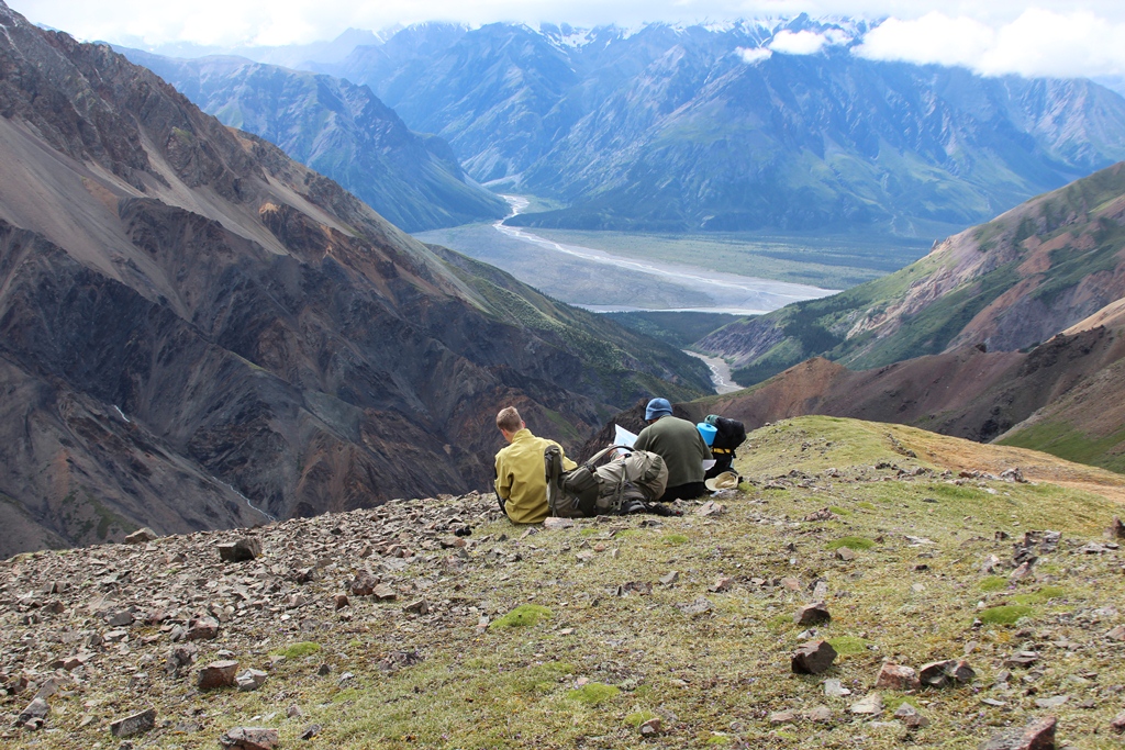
The views were astounding. Across the Donjek valley was a mirror-like opening where Spring Creek flows into the Donjek River.
![]()
We needed to find a route down to Hoge Creek. The way is steep and dangerous. It is loose scree and many gullies lead to cliffs. A wrong move here could spell disaster for the team.
![]()

We hiked around a bit, exploring the scenic and geological wonders of the beautiful pass.
![]()

The gullies look decieving. It is hard to get asense of scale form this picture, but it was steep and long... possibly ending in a cliff. We kept looking for a safer route.
![]()

Dahl Sheep were in abundance. We had them as company for the entire evening.
![]()

This was the most awesome camp I think we ever had. Click to enlarge. You will notice our tents to the left of center. Mt Hoge and other glaciers were nestled in behind us.
![]()

This looks to be a possible route down. It snowed that night. When we got up the next morning it was very, very foggy. We couldn't see the bottom of the gullies. Fortunately, I took GPS readings the evening before. We descended down into the fog and then....
To be continued in Part 2 ....
Skip to the end and read Part 3 (The Final Chapter) here:
No comments:
Post a Comment