GrizzLee Stories From the North : Episode 4 - Good Times,
Good Friends, and Good Roads (Part1)

After the spiritual experience at the Salmon Glacier, the
weather really turned for the best. I left Joe and Chip at Dease Lake. They
were taking a side trip down the Stikine Canton to Telegraph Creek. I can
personally testify that this is a great ride and personal favorite of mine.
However, this time, I wanted to make time to tackle the Canol Road and wrap up
some unfinished business up north.


I left Dease Lake heading for Watson Lake, Yukon and
points north. Along the way, I would pass by several scenic lakes and rivers.

A stop at Jade City is also a must. In my many years of
traveling North, Jade city has always been a favorite. Free coffee and hot
cocoa has been a blessing for those times when I pulled off the Cassiar in
adverse weather. The Jade City region
is home to 92% of the world's nephrite jade. The grounds around the store are
interesting to tour with its antique dozers, excavators, dump trucks, mining
cars as well as big samples of Jade rock being cut up on diamond saws. Inside
the store, you may meet the owners and see beautiful carvings of jade
figurines (bears, moose, goats, etc..) as well as jewelry. If you are lucky,
you may appear the reality TV series being filmed there known as Jade Fever. Jade
Fever documents the mining efforts of the Cassiar Mountain Jade Store, and the
Bunce family. They mine hard rock deposits and placer deposits left by glaciers
for over 40 years.

From there I made my way up past Good Hope Lake and then
up to the Yukon Border. Beyond Good Hope Lake, the trees and terrain take on
another look that is more akin the Yukon. The trees, flora and fauna stay
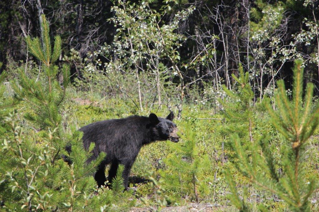
consistent from this point on until one reaches the arctic area. Before leaving
the far northern border of British Columbia into the Yukon, I was greeted by a
friendly black bear. This was but one of the numerous bears I saw along the
Cassiar Hwy.


Once in the Yukon, I made my way over to Watson Lake. I
stopped in at Kathy’s Kitchen, which is the best restaurant in Watson Lake.
Watson Lake isn’t all the big, so there isn’t much to choose from. I had a burger
and fries along with some good company. I met two fellas form Germany who were
touring a big chunk of Canada on a budget!! We chatted a bit and they wished me
luck.
It was now mid afternoon… or maybe later… time becomes
somewhat irrelevant in these northern climates with long summer days full of
sunshine. However, I noticed a humongous column of smoke in the direction I was
heading, up the Robert Campbell Highway.
I took a quick ride through the Sign Post Forest to the visitor Center. The Sign Post Forest is a collection of signs at Watson Lake. It is one of the most famous of the landmarks along the Alaska Highway started by homesick GIs in 1942 whom erected the signposts for their hometown usually 1000s of miles away. Visitors have added their own signs to “forest”. Current count has the number of signs approaching 100000.
I took a quick ride through the Sign Post Forest to the visitor Center. The Sign Post Forest is a collection of signs at Watson Lake. It is one of the most famous of the landmarks along the Alaska Highway started by homesick GIs in 1942 whom erected the signposts for their hometown usually 1000s of miles away. Visitors have added their own signs to “forest”. Current count has the number of signs approaching 100000.


Now, back to that fire I was witnessing. It was huge. I
inquired at the visitor center about the road conditions and was told that the
Robert Campbell highway was still open, but that I would be passing through a
very heavy cloud of smoke… eeek!! It was all caused by lightening. I managed to
get some video of the event as I rode through it. Day became night and the sun
was blocked out. From there I made my way
to Simpson Lake and then up to the Nahanni Range Road junction. (Side note, the
Nahanni Range Road is a road that I rode up three years previously. It is an
amazing ride into the heart of some of the loneliest lands I have ever
experienced. I rode it solo and there are no facilities (400 mile round trip
without fuel stations). I plan to go again, but next time with a buddy for
safety reasons (it’s remote and full of grizzlies) and more than 2 days to
explore.).
It was now getting into the evening and maybe even a bit
later. I was hoping to make my way to Frances Lake for the night. However, I
was continuously distracted by the beauty of the mountains, ponds, lakes,
rivers and the wildlife I saw along the way. The Robert Campbell Hwy is a
highway by name only. Rest assured, it is a wilderness gravel road and it
became quite narrow at times and I noted more than 5 bear sightings along the
way. I was having a great time soaking up the sun, the warm weather from the
seat of my bike. It was a great day.

I eventually pulled into Frances Lake Campground. I was
able to snag a lakeside campsite next to a Dutch couple who live in the Yukon
during the summer months. The lake itself, is the largest lake in Southeast
Yukon. Several rivers and creeks flow into Frances Lake, forming extensive
deltas. It was stunningly beautiful in the evening sun. The evening was surreal
as I cooked my meal and enjoyed a cigar, sharing a beer while sitting around a
campfire looking down the big lake. It was a big day of riding, my spirits were
high and I looked forward to an even bigger day tomorrow.
The next day started out
fantastic. The warm sun coddled me as I lay in my tent with my tent door open
to full views down the lake. PERFECT! I made some breakfast, packed and said
goodbye to my Dutch Campmates.
Stay tuned for Part 2 of GrizzLee Stories From the North : Episode 4 - Good Times,
Good Friends, and Good Road
No comments:
Post a Comment